
File:Centre of Fordingbridge - geograph.org.uk - 1525645.jpg
Degöna resoluziun plü alta desponibla.
Centre_of_Fordingbridge_-_geograph.org.uk_-_1525645.jpg (640 × 426 pixels, dimenjiun dl file: 203 KB, MIME type: image/jpeg)
Ressumé
| Descriziun |
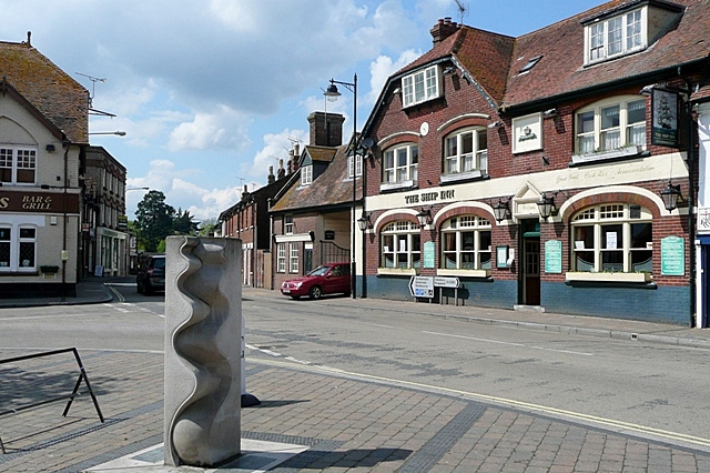
English: Centre of Fordingbridge This is the junction of Provost Street (left), Shaftesbury Street (ahead) and High Street (right) that can be regarded as the town centre. The Ship Inn probably indicates a time when the River Avon was navigable as far as the town, and the town name clearly indicates that this was the ford and later the bridge over the river. I would appreciate information about the sculpture in the foreground. The sculpture is by Paul Wilson of Salisbury. (http://wilsonsculpture.co.uk/gallery.htm) |
| Data | |
| Funtana | From geograph.org.uk |
| Autur | Graham Horn |
| Atribuzion (richiesto dalla licenza) | Graham Horn / Centre of Fordingbridge / |
| Luogo dello scatto | | Posizione di questa e altre immagini su: OpenStreetMap |
|---|
_heading:292.00&language=lld)
| Posizione del soggetto | | Posizione di questa e altre immagini su: OpenStreetMap |
|---|
_heading:292.00&language=lld)
Lizënza

|
Questa immagine proviene dalla collezione del progetto Geograph. Vedi questa fotografia sul sito web di Geograph per visualizzare i dettagli relativi al fotografo. Il copyright di questa immagine appartiene a Graham Horn ed è pubblicata secondo i termini della licenza Creative Commons Attribuzione-Condividi allo stesso modo 2.0.
|
Questo file è disponibile in base alla licenza Creative Commons Attribuzione-Condividi allo stesso modo 2.0 Generico
Atribuzion: Graham Horn
- Tu ies liede:
- da spartì – per cupié, spartësc y manda l lëur
- da mudé – da adaté al lëur
- A chësta condizions:
- atribuzion – Tu mues atribué l lëur te la maniera che à spiegà l autëur o chël che à la lizënza (ma nia te na maniera che l smea che ëi te paiessa).
- fá na condivijiun tla medema manira – Sce te mudes o svilupeies chësc test, pudres mé spartì ora l lëur sota la medema lizënza o una che ti smea a chësta same or compatible license
Storia dl documënt
Druca sun na data/ëura per udëi l documënt coche l fo te chël mumënt.
| Data/Ëura | Miniatura | Grandëza | utënt | Cumentar | |
|---|---|---|---|---|---|
| atuel | 04:51, 3 mer 2011 | | 640 × 426 (203 KB) | GeographBot | == {{int:filedesc}} == {{Information |description={{en|1=Centre of Fordingbridge This is the junction of Provost Street (left), Shaftesbury Street (ahead) and High Street (right) that can be regarded as the town centre. The Ship Inn probably indicates a |
Coche l document ie stat adurvà
Chësta plata adroa chësc documënt:
Coche l documënt ie stat adurvà ntëur l mond
Ënghe chësta wikis adroa chësc documënt:
- Adurvà sun azb.wikipedia.org
- Adurvà sun ceb.wikipedia.org
- Adurvà sun cy.wikipedia.org
- Adurvà sun de.wikipedia.org
- Adurvà sun en.wikivoyage.org
- Adurvà sun es.wikipedia.org
- Adurvà sun fa.wikipedia.org
- Adurvà sun fr.wikipedia.org
- Adurvà sun ga.wikipedia.org
- Adurvà sun it.wikipedia.org
- Adurvà sun nl.wikipedia.org
- Adurvà sun ro.wikipedia.org
- Adurvà sun sv.wikipedia.org
- Adurvà sun www.wikidata.org