
File:Grossdeutsches Reich NS Administration 1944.png
Documënt uriginel (2 615 × 2 030 pixels, dimenjiun dl file: 250 KB, MIME type: image/png)
Ressumé
| Descriziun |
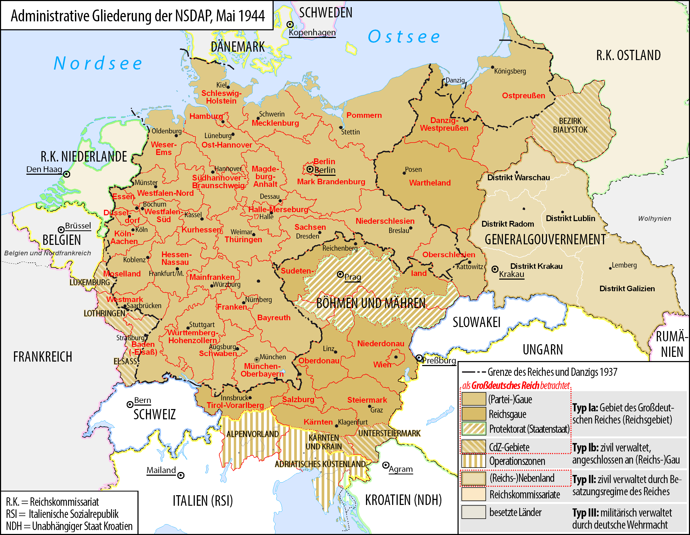
Deutsch: Karte der administrativen Gliederung des Großdeutschen Reiches durch die NSDAP 1944.
English: Map of the administrative division of the Greater German Reich ("Großdeutsches Reich"/"Großdeutschland"/"Greater German Empire"/"Greater Germany") by the NSDAP 1944 (in German).
Polski: Mapa Wielkiej Rzeszy Niemieckiej (1944) |
||
| Data | |||
| Funtana | Opera personala | ||
| Autur | Bennet Schulte | ||
| Lizënza (Tó ca danü chësc file) |
|
||
| Altre versioni |
|


Lizënza
- Tu ies liede:
- da spartì – per cupié, spartësc y manda l lëur
- da mudé – da adaté al lëur
- A chësta condizions:
- atribuzion – Tu mues atribué l lëur te la maniera che à spiegà l autëur o chël che à la lizënza (ma nia te na maniera che l smea che ëi te paiessa).
- fá na condivijiun tla medema manira – Sce te mudes o svilupeies chësc test, pudres mé spartì ora l lëur sota la medema lizënza o una che ti smea a chësta same or compatible license

|
AL é la lizënza da copié, da dé inant y/o müdé chësc documënt aladô dla lizënza GNU Free Documentation License, Verjiun 1.2 o vigni atra verjiun suandënta publicada dala Free Software Foundation; zënza seziuns che ara ne vá nia da mudé, zënza test söl cuertl ca dant y do ia. Na copia dla lizënza é tla seziun cun le titul Test dla GNU Free Documentation License. |
Storia dl documënt
Druca sun na data/ëura per udëi l documënt coche l fo te chël mumënt.
| Data/Ëura | Miniatura | Grandëza | utënt | Cumentar | |
|---|---|---|---|---|---|
| atuel | 07:23, 3 jun 2017 | | 2 615 × 2 030 (250 KB) | Exec | auf vielfachen Wunsch wurden die zum Zeitpunkt der Darstellung existierenden militärisch verwalteten Gebiete "Wolhynien" (Rest von RK Ukraine) sowie "Belgien und Nordfrankreich" beschriftet und abgegrenzt wenn abweichend von Staatsgrenzen |
| 02:26, 4 fau 2016 |  | 2 615 × 2 030 (344 KB) | Exec | Reverted to version as of 10:37, 11 September 2015 (UTC): thematic content don't include military administative units, see https://commons.wikimedia.org/wiki/File_talk:Greater_German_Reich_NS_Administration_1944.png#Problems_with_the_map | |
| 17:04, 6 dez 2015 |  | 2 607 × 2 022 (579 KB) | Braganza | Reverted to version as of 22:32, 7 July 2014 (UTC) | |
| 12:37, 11 sët 2015 |  | 2 615 × 2 030 (344 KB) | RokerHRO | optipng -i0 -zc1-9 -zm1-9 -zs0-3 -f0-5 -i0 → 35.13% decrease | |
| 11:32, 27 jun 2015 |  | 2 615 × 2 030 (530 KB) | Exec | - clearified phrase for dotted line (statt "dargestellt als", "als betrachtet" | |
| 11:23, 27 jun 2015 |  | 2 616 × 2 029 (530 KB) | Exec | - added subdevision of the Operationszonen - fixed explanation of red dotted line (visualisation in cartographic materials as Großdeutsches Reich) and exclude Operationszonen | |
| 02:18, 3 aur 2015 |  | 2 607 × 2 022 (231 KB) | Exec | Reverted to version as of 21:17, 17 July 2014 because no fixes are identified but some black objects are switched to grey with out logic and benefit.undaries to grey | |
| 09:08, 29 mer 2015 |  | 2 607 × 2 022 (345 KB) | DIREKTOR | Small fix. | |
| 23:17, 17 lug 2014 |  | 2 607 × 2 022 (231 KB) | Execger | Boundaries of millitary administration is not part of the thematic content. | |
| 00:32, 8 lug 2014 |  | 2 607 × 2 022 (579 KB) | Victor falk~commonswiki | belgien und nordfrankreich |
Coche l document ie stat adurvà
Chësta plata adroa chësc documënt:
Coche l documënt ie stat adurvà ntëur l mond
Ënghe chësta wikis adroa chësc documënt:
- Adurvà sun cs.wikipedia.org
- Adurvà sun da.wikipedia.org
- Adurvà sun de.wikipedia.org
- Gau
- Geschichte Österreichs
- Generalgouvernement
- Beneš-Dekrete
- Reichsstatthalter
- Reichsgau
- Danzig-Westpreußen
- Deutsche Frage
- Geschichte der Steiermark
- Kriegsschauplatz Mittelmeerraum
- NS-Staat
- Diskussion:Liste der größten deutschen Städte
- Liste der Wappen in Deutschland
- Geschichte Niederösterreichs
- Deutschland
- Operationszone Adriatisches Küstenland
- Diskussion:Deutschland/Archiv/2
- Geschichte Oberösterreichs
- Ostmarkgesetz
- Portal Diskussion:Nationalsozialismus/Archiv/2010
- Liste der Postleitregionen in Deutschland
- Wikipedia:Kartenwerkstatt/Archiv/Zurückgewiesene und zurückgestellte Aufträge 2012
- Portal Diskussion:Nationalsozialismus/Archiv/2014
- Diskussion:Uschi Nerke
- Wikipedia:Redaktion Geschichte/Archiv/2023/Feb
- Adurvà sun frr.wikipedia.org
- Adurvà sun fr.wikipedia.org
- Adurvà sun fr.wiktionary.org
- Adurvà sun gl.wikipedia.org
- Adurvà sun hak.wikipedia.org
- Adurvà sun he.wikipedia.org
- Adurvà sun it.wikipedia.org
- Adurvà sun ja.wikipedia.org
- Adurvà sun lb.wikipedia.org
Mostra utilisaziun globala de chësc file.