
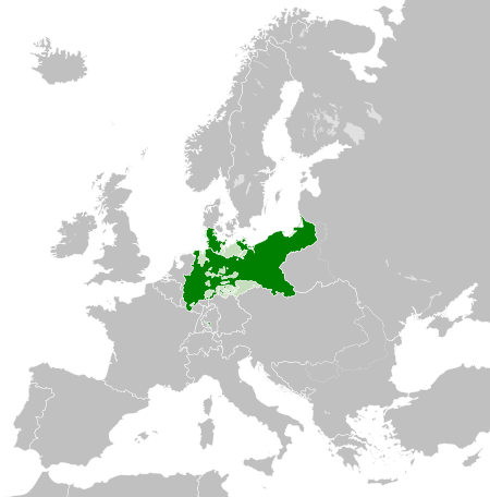
File:Kingdom of Prussia 1870.svg

Dimensioni di questa anteprima PNG per questo file SVG: 450 x 456 pixel. Autra resoluzions: 237 x 240 pixel | 474 x 480 pixel | 758 x 768 pixel | 1 011 x 1 024 pixel | 2 021 x 2 048 pixel.
Documënt uriginel (file tl format SVG, dimenjiuns nominales 450 × 456 pixels, dimenjiun dl file: 705 KB)
Ressumé
Questa grafica vettoriale non specificata secondo il W3C è stata creata con Inkscape .


.svg)
.svg)
.svg)
.svg)
.svg)


.svg)
.svg)
.svg)


.png)
.png)


.svg)


.svg)

.svg)


.svg)
.svg)
.svg)
.svg)


.svg)
.png)


.svg)


.svg)
.svg)


.svg)


.svg)


.svg)
.svg)
.svg)
.svg)
.svg)
.svg)
.svg)
_cropped.svg)
.svg)
.svg)
.svg)
.svg)
.svg)
.svg)
.svg)
.svg)
.svg)
.svg)
.svg)
.svg)
.svg)
.svg)
.svg)
.svg)
.svg)
.svg)
.svg)
.svg)
.svg)
.svg)
.svg)
.svg)
.svg)
.svg)
.svg)
.svg)
.svg)
.svg)
.svg)
.svg)
.svg)
.svg)
.svg)
.svg)
.svg)
.svg)
.svg)
.svg)
.svg)
.svg)
.svg)
.svg)
.svg)
Lizënza
Questo file è disponibile in base alla licenza Creative Commons Attribuzione-Condividi allo stesso modo 4.0 Internazionale
- Tu ies liede:
- da spartì – per cupié, spartësc y manda l lëur
- da mudé – da adaté al lëur
- A chësta condizions:
- atribuzion – Tu mues atribué l lëur te la maniera che à spiegà l autëur o chël che à la lizënza (ma nia te na maniera che l smea che ëi te paiessa).
- fá na condivijiun tla medema manira – Sce te mudes o svilupeies chësc test, pudres mé spartì ora l lëur sota la medema lizënza o una che ti smea a chësta same or compatible license
Storia dl documënt
Druca sun na data/ëura per udëi l documënt coche l fo te chël mumënt.
| Data/Ëura | Miniatura | Grandëza | utënt | Cumentar | |
|---|---|---|---|---|---|
| atuel | 04:54, 1 jun 2016 | | 450 × 456 (705 KB) | Alphathon | Various corrections to the states of the North German Confederation |
| 07:22, 31 mei 2016 |  | 450 × 456 (662 KB) | Alphathon | Minor corrections (Tarasp and post-1818 German Confederation border change) | |
| 04:40, 31 mei 2016 |  | 450 × 456 (662 KB) | Alphathon | == {{int:filedesc}} == {{Inkscape}} {{Information |Description={{en|A map of the en:Kingdom of Prussia within the North German Confederation and within Europe circa 1870 CE.}} |Source= {{Derived from|Blank_map_of_Europe.svg|display=50}} |Da... |
Coche l document ie stat adurvà
Chësta plata adroa chësc documënt:
Coche l documënt ie stat adurvà ntëur l mond
Ënghe chësta wikis adroa chësc documënt:
- Adurvà sun af.wiktionary.org
- Adurvà sun ar.wikipedia.org
- Adurvà sun bn.wikipedia.org
- Adurvà sun ckb.wikipedia.org
- Adurvà sun en.wikipedia.org
- Adurvà sun eo.wiktionary.org
- Adurvà sun es.wikipedia.org
- Adurvà sun es.wiktionary.org
- Adurvà sun eu.wikipedia.org
- Adurvà sun fa.wikipedia.org
- Adurvà sun fi.wikipedia.org
- Adurvà sun he.wikipedia.org
- Adurvà sun hu.wikipedia.org
- Adurvà sun is.wikipedia.org
- Adurvà sun it.wikipedia.org
- Adurvà sun li.wiktionary.org
- Adurvà sun lt.wikipedia.org
- Adurvà sun mn.wikipedia.org
- Adurvà sun pl.wikipedia.org
- Adurvà sun rue.wikipedia.org
- Adurvà sun ru.wikipedia.org
- Adurvà sun ru.wiktionary.org
- Adurvà sun sk.wikipedia.org
- Adurvà sun szl.wikipedia.org
- Adurvà sun tr.wikipedia.org
- Adurvà sun uk.wikipedia.org
- Adurvà sun uz.wikipedia.org
- Adurvà sun xmf.wikipedia.org
- Adurvà sun zh.wikipedia.org