File:Ocean drainage.png
Contenuti della pagina non supportati in altre lingue.
Da Wikipedia

Documënt uriginel(1 256 × 656 pixels, dimenjiun dl file: 75 KB, MIME type: image/png)

Chësc documënt ven da Wikimedia Commons y po unì adurvà per autri proiec. Dessot ie la descrizion te la file description page.

Ressumé

Questa immagine (categorizzazione automatica: map) o tutte le immagini in questa categoria o galleria dovrebbero essere ricreate usando grafica vettoriale come file SVG. Questo offre diversi vantaggi: vedi Commons:Media for cleanup per maggiori informazioni. Se è disponibile una versione in formato SVG di questa immagine, per favore caricala. Dopo aver caricato un file SVG, sostituisci questo avviso con il template {{Vector version available|nome_immagine.svg}}.
Descriziun
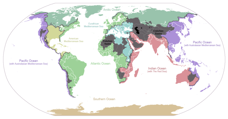
English: I made this map and hereby release it into the public domain. It shows the drainage basins for the major oceans and seas; grey areas are endorheic basins that do not drain to the ocean. Data is from the USGS Hydro1k project; information for Saskatchewan corrected by information from the Commission for Environmental Cooperation -- Citynoise
Description in large font size is used for oceans, in smaller font size is used for mediterranean seas. Only these mediterranean seas are listed which correspond to the definition of german Geographer Ernst Neef: A mediterranean sea is a sea between two Continents. Also found here: de:Mittelmeer --W like wiki (talk) 00:55, 12 March 2011 (UTC)
Français : Carte du monde des bassins versants. Les zones de couleur anthracite représentent les bassins endoréiques, qui ne sont reliés à aucun océan.
Čeština: Úmoří světových oceánů, popř. významných moří či zálivů. Legenda úmoří: fialová - Tichý oceán, růžová - Indický oceán, zelená - Atlantický oceán, azurová - Severní ledový oceán, béžová - Jižní oceán, modrá - Mexický záliv, světle modrá - Středozemní moře, šedá - oblast neústící ve světovém oceánu
Data 24 jené 2007 (data di caricamento originaria)
Funtana Trasferito da en.wikipedia su Commons.
Autur Citynoise di Wikipedia in inglese
Altre versioni File:Major endorheic basins.png

Lizënza

Public domain Quest'opera è stata rilasciata nel pubblico dominio dal suo autore, Citynoise di Wikipedia in inglese. Questa norma si applica in tutto il mondo.
In alcuni paesi questo potrebbe non essere legalmente possibile. In tal caso:
Citynoise garantisce a chiunque il diritto di utilizzare quest'opera per qualsiasi scopo, senza alcuna condizione, a meno che tali condizioni siano richieste dalla legge.

Registro originale del caricamento

La pagina di descrizione originale era qui. Tutti i nomi utente che seguono sono riferiti a en.wikipedia.
  • 2007-05-20 17:59 Bolonium 1256×656×8 (50194 bytes) I made this map and hereby release it into the public domain. It shows the drainage basins for the major oceans and seas; grey areas are endorheic basins that do not drain to the ocean. -- [[User:Citynoise|Citynoise]] == Licensing == {{self
  • 2007-01-24 07:21 Citynoise 1256×656×8 (63359 bytes) I made this map and hereby release it into the public domain. It shows the drainage basins for the major oceans and seas; grey areas are endorheic basins that do not drain to the ocean.
  • 2007-01-24 06:09 Citynoise 1256×656×8 (57358 bytes) I made this map and hereby release it into the public domain. It shows the drainage basins for the major oceans and seas; grey areas are endorheic basins that do not drain to the ocean.
  • 2007-01-24 05:10 Citynoise 1256×656×8 (56360 bytes) I made this map and hereby release it into the public domain. It shows the drainage basins for the major oceans and seas; grey areas are endorheic basins that do not drain to the ocean.
  • 2007-01-24 04:55 Citynoise 1256×656×8 (56373 bytes) I made this map and hereby release it into the public domain. It shows the drainage basins for the major oceans and seas; grey areas are endorheic basins that do not drain to the ocean.

Didascalie

Aggiungi una brevissima spiegazione di ciò che questo file rappresenta
Drainage basins of the world, colored by ocean outlet. Endorheic basins not draining to an ocean are colored dark gray. Continental divides are indicated by dark lines.

Elementi ritratti in questo file

raffigura italiano

24 jen 2007

Storia dl documënt

Druca sun na data/ëura per udëi l documënt coche l fo te chël mumënt.

Data/ËuraMiniaturaGrandëzautëntCumentar
atuel01:25, 7 uto 2015Miniatura de la version de la 01:25, 7 uto 20151 256 × 656 (75 KB)AcidSnowFixed Somalia.
02:39, 12 mer 2011Miniatura de la version de la 02:39, 12 mer 20111 256 × 656 (76 KB)W like wikiInsert Description. Big font size is used for oceans, smaller font size is used for mediterranean seas.
13:13, 30 jun 2009Miniatura de la version de la 13:13, 30 jun 20091 256 × 656 (40 KB)U7vGuntransparentize background,improve some details.
22:45, 26 lug 2008Miniatura de la version de la 22:45, 26 lug 20081 256 × 656 (62 KB)Citynoise{{Information |Description=added endorheic basins in Saskatchewan. |Source=my own work |Date=July 2008 |Author=Citynoise |Permission=all rights released |other_versions= }}
21:46, 27 nuë 2007Miniatura de la version de la 21:46, 27 nuë 20071 256 × 656 (49 KB)File Upload Bot (Magnus Manske) {{BotMoveToCommons|en.wikipedia}} {{Information |Description={{en|I made this map and hereby release it into the public domain. It shows the drainage basins for the major oceans and seas; grey areas are en:endorheic basins that do not drain to the

Chësta plata adroa chësc documënt:

Coche l documënt ie stat adurvà ntëur l mond

Ënghe chësta wikis adroa chësc documënt:

Mostra utilisaziun globala de chësc file.

Metadac