
File:Palau - Location Map (2013) - PLW - UNOCHA.svg

Documënt uriginel (file tl format SVG, dimenjiuns nominales 250 × 250 pixels, dimenjiun dl file: 1,12 MB)
_-_PLW_-_UNOCHA.svg)
Ressumé
| Descriziun |
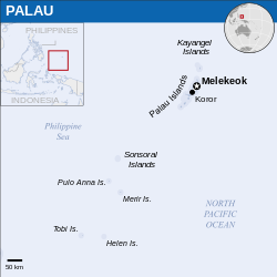
English: Locator map of Palau. |
| Data | |
| Funtana |
English: Palau Locator Map (ReliefWeb) |
| Autur | |
| SVG sviluppo | Questa mappa in grafica vettoriale è stata creata con Inkscape. |
Lizënza
- Tu ies liede:
- da spartì – per cupié, spartësc y manda l lëur
- da mudé – da adaté al lëur
- A chësta condizions:
- atribuzion – Tu mues atribué l lëur te la maniera che à spiegà l autëur o chël che à la lizënza (ma nia te na maniera che l smea che ëi te paiessa).
 This map is part of a collection of 216 free country maps, created by the UN Office for the Coordination of Humanitarian Affairs (OCHA), to be used in print, web or broadcast products.
The ReliefWeb Location Maps released here are maps that highlight a country, its capital, major populated places and the surrounding regions. Attribution Requirements
Using the map without modifications: ensure that the sources and the disclaimer are below the map. Credit as follows: "Credit: OCHA". For use with alteration: remove the OCHA logo and disclaimer following any modification to the map, but keep the data sources as mentioned below the map. Credit the modified map as follows: "Based on OCHA map". You are responsible for the content of your map. We are keen to receive your feedback and hear how you used OCHA's maps. We would be grateful if you would notify us by e-mail and share your work with us. UN Disclaimer
The designations employed and the presentation of material of this map do not imply the expression of any opinion whatsoever on the part of the Secretariat of the United Nations concerning the legal status of any country, territory, city or area or of its authorities or concerning the delimitation of its frontiers or boundaries. |

|
Il testo informativo (per esempio ora e data), una volta presente sull'immagine stessa, è stato spostato nei metadati dell'immagine e/o nella pagina di descrizione. Ciò facilita il riutilizzo dell'immagine in più contesti e più lingue, e rende il testo più facile da trattare e cercare. Commons scoraggia l'inserimento di informazioni testuali visibili nell'immagine. Tutte le licenze accettate su Commons permettono questo tipo di operazione come se si trattasse di un'opera derivata.
Se le informazioni di attribuzione sono state rimosse e l'immagine non è nel pubblico dominio o free use, sostituisci questo template con {{Attribution metadata from licensed image}}.
|
Storia dl documënt
Druca sun na data/ëura per udëi l documënt coche l fo te chël mumënt.
| Data/Ëura | Miniatura | Grandëza | utënt | Cumentar | |
|---|---|---|---|---|---|
| atuel | 09:43, 10 mer 2023 | | 250 × 250 (1,12 MB) | Illchy | File uploaded using svgtranslate tool (https://svgtranslate.toolforge.org/). Added translation for id. |
| 04:04, 29 dez 2022 |  | 250 × 250 (1,12 MB) | Wikijahnn | File uploaded using svgtranslate tool (https://svgtranslate.toolforge.org/). Added translation for ca. | |
| 09:32, 3 aur 2016 |  | 250 × 250 (1,12 MB) | Wereldburger758 | Resized page to drawing. Removal watermark. Validation of image. | |
| 02:53, 8 mei 2014 |  | 254 × 254 (1,08 MB) | UN OCHA maps bot | == {{int:filedesc}} == {{Information |description={{en|1=Locator map of Palau.}} |date=2013 |source={{en|1=[http://reliefweb.int/map/palau/palau-location-map-2013 Palau Locator Map (ReliefWeb)]}} |author={{en|1=[[w:en:United Nations Offi... |
Coche l document ie stat adurvà
Chësta plata adroa chësc documënt:
Coche l documënt ie stat adurvà ntëur l mond
Ënghe chësta wikis adroa chësc documënt:
- Adurvà sun ast.wikipedia.org
- Adurvà sun bcl.wikipedia.org
- Adurvà sun bg.wikipedia.org
- Adurvà sun bjn.wikipedia.org
- Adurvà sun bn.wikipedia.org
- Adurvà sun ca.wikipedia.org
- Adurvà sun cs.wikipedia.org
- Adurvà sun cy.wikipedia.org
- Adurvà sun dty.wikipedia.org
- Adurvà sun en.wikipedia.org
- Adurvà sun eu.wikipedia.org
- Adurvà sun fa.wikipedia.org
- Adurvà sun gu.wikipedia.org
- Adurvà sun hi.wikipedia.org
- Adurvà sun id.wikipedia.org
- Adurvà sun it.wikipedia.org
- Adurvà sun kcg.wikipedia.org
- Adurvà sun mn.wikipedia.org
- Adurvà sun my.wikipedia.org
- Adurvà sun ps.wikipedia.org
- Adurvà sun ru.wikipedia.org
- Adurvà sun sat.wikipedia.org
- Adurvà sun sd.wikipedia.org
- Adurvà sun sr.wikipedia.org
- Adurvà sun sv.wikipedia.org
- Adurvà sun tt.wikipedia.org
- Adurvà sun www.wikidata.org
_-_PLW_-_UNOCHA.svg)