
File:Woking Town Square - geograph.org.uk - 40908.jpg
Degöna resoluziun plü alta desponibla.
Woking_Town_Square_-_geograph.org.uk_-_40908.jpg (640 × 427 pixels, dimenjiun dl file: 85 KB, MIME type: image/jpeg)
Ressumé
| Descriziun |
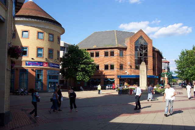
English: Woking Town Square. In 1838 when the railway arrived, Woking town centre was open heathland. The town developed in a fairly piecemeal fashion and had reached a form of completion by the mid-1980s, when redevelopment began again. A short-lived town centre swimming pool disappeared as part of those changes, to be replaced by the Pool in the Park. The present form of the town centre, including the modern library, the Peacocks shopping centre, and the refashioned Wolsey Way centre date from that time. |
| Data | |
| Funtana | From geograph.org.uk |
| Autur | Ron Strutt |
| Atribuzion (richiesto dalla licenza) | Ron Strutt / Woking Town Square / |
| Posizione del soggetto | | Posizione di questa e altre immagini su: OpenStreetMap |
|---|
_&language=lld)
Lizënza

|
Questa immagine proviene dalla collezione del progetto Geograph. Vedi questa fotografia sul sito web di Geograph per visualizzare i dettagli relativi al fotografo. Il copyright di questa immagine appartiene a Ron Strutt ed è pubblicata secondo i termini della licenza Creative Commons Attribuzione-Condividi allo stesso modo 2.0.
|
Questo file è disponibile in base alla licenza Creative Commons Attribuzione-Condividi allo stesso modo 2.0 Generico
Atribuzion: Ron Strutt
- Tu ies liede:
- da spartì – per cupié, spartësc y manda l lëur
- da mudé – da adaté al lëur
- A chësta condizions:
- atribuzion – Tu mues atribué l lëur te la maniera che à spiegà l autëur o chël che à la lizënza (ma nia te na maniera che l smea che ëi te paiessa).
- fá na condivijiun tla medema manira – Sce te mudes o svilupeies chësc test, pudres mé spartì ora l lëur sota la medema lizënza o una che ti smea a chësta same or compatible license
- Remove redundant categories and try to put this image in the most specific category/categories
- Remove this template
- The location categories are based on information from this geonames tool and this OpenStreetMap tool combined with a database. You can also have a look at this tool from mysociety.
- The topic category from Geograph was Town centre (find similar images centre at Geograph)
Storia dl documënt
Druca sun na data/ëura per udëi l documënt coche l fo te chël mumënt.
| Data/Ëura | Miniatura | Grandëza | utënt | Cumentar | |
|---|---|---|---|---|---|
| atuel | 22:29, 30 jen 2010 | | 640 × 427 (85 KB) | GeographBot | == {{int:filedesc}} == {{Information |description={{en|1=Woking Town Square. In 1838 when the railway arrived, Woking town centre was open heathland. The town developed in a fairly piecemeal fashion and had reached a form of completion by the mid-1980s, |
Coche l document ie stat adurvà
Chësta plata adroa chësc documënt:
Coche l documënt ie stat adurvà ntëur l mond
Ënghe chësta wikis adroa chësc documënt:
- Adurvà sun af.wikipedia.org
- Adurvà sun azb.wikipedia.org
- Adurvà sun az.wikipedia.org
- Adurvà sun ceb.wikipedia.org
- Adurvà sun cs.wikipedia.org
- Adurvà sun en.wikipedia.org
- Adurvà sun fa.wikipedia.org
- Adurvà sun fi.wikipedia.org
- Adurvà sun hu.wikipedia.org
- Adurvà sun ja.wikipedia.org
- Adurvà sun ko.wikipedia.org
- Adurvà sun nl.wikipedia.org
- Adurvà sun nn.wikipedia.org
- Adurvà sun no.wikipedia.org
- Adurvà sun pl.wikipedia.org
- Adurvà sun pl.wikivoyage.org
- Adurvà sun simple.wikipedia.org
- Adurvà sun sv.wikipedia.org
- Adurvà sun szl.wikipedia.org
- Adurvà sun ur.wikipedia.org
- Adurvà sun zh.wikipedia.org