
File:Arabi20FebLeBeau1.jpg
Dimenjiuns de chësta odüda danfora:800 x 462 pixel. Autra resoluzions: 320 x 185 pixel | 640 x 369 pixel | 1 024 x 591 pixel | 1 280 x 738 pixel | 2 432 x 1 403 pixel.
Documënt uriginel (2 432 × 1 403 pixels, dimenjiun dl file: 984 KB, MIME type: image/jpeg)
Ressumé
| Descriziun |
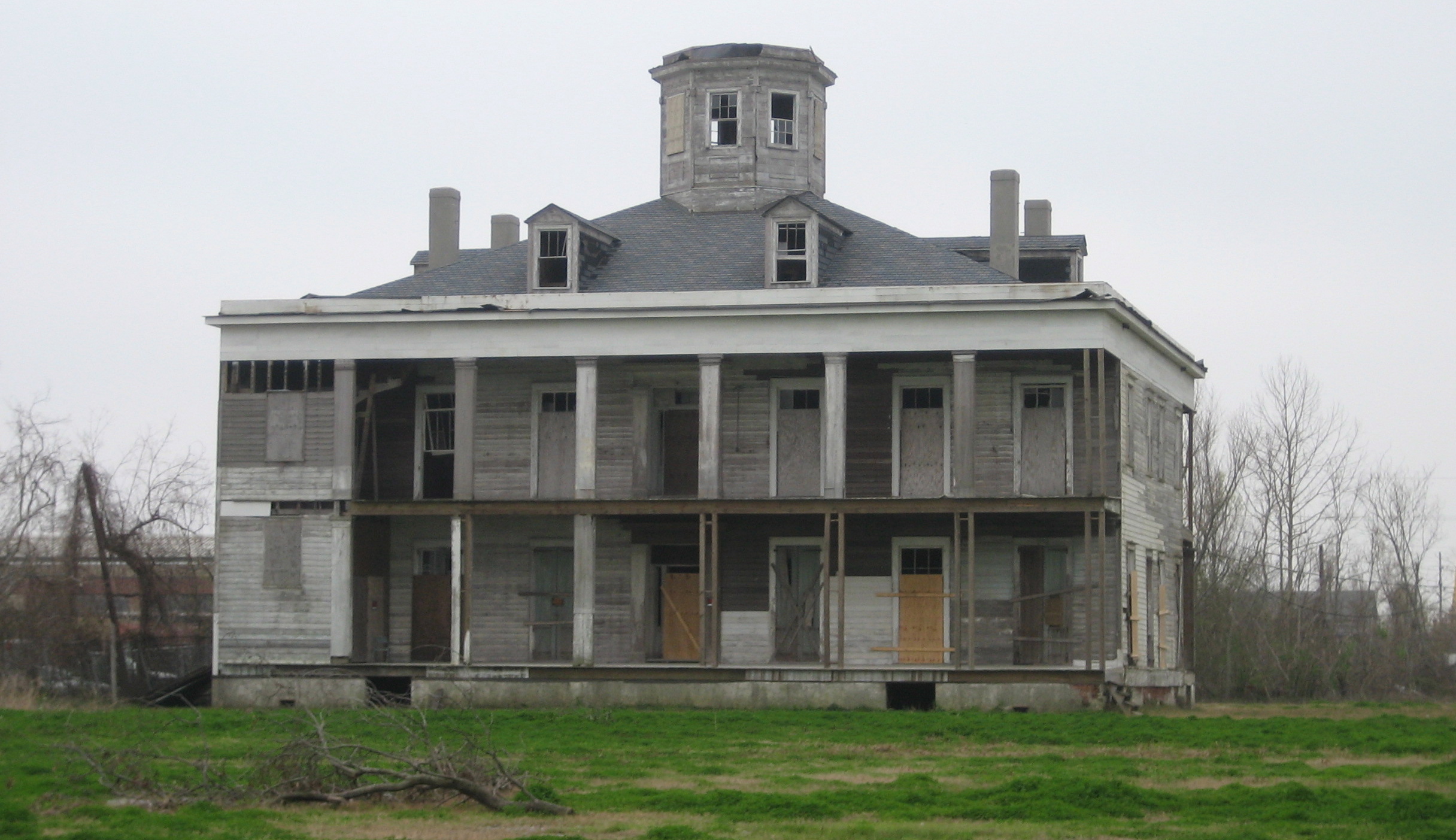
English: LeBeau Plantation, Arabi, Louisiana. The 1854 plantation house, Photographed by Infrogmation of New Orleans in 2006. It was a hotel and gambling establishment in the mid 20th century, destroyed by arson in 2013. The property was owned by Joseph Meraux and in his will was left to Arlene Soper Meraux after a court battle to prove a common law marriage. After her death, months prior to Hurricane Katrina, she left this plantation and several other properties to a commission made of several St. Bernard Parish politicians. Before the storm and later arson, a committee had planned on making large and pricey renovations to Le Beau hoping to bring more tourism into the area.
|
||
| Data | |||
| Funtana | Photo by Infrogmation of New Orleans | ||
| Autur | Infrogmation of New Orleans | ||
| Lizënza (Tó ca danü chësc file) |
May be reused with photographer attribution in accordance with any of the licenses listed by the author. Reuse without attribution is a violation of copyright. |
Lizënza
Io, detentore del copyright su quest'opera, dichiaro di pubblicarla con le seguenti licenze:

|
AL é la lizënza da copié, da dé inant y/o müdé chësc documënt aladô dla lizënza GNU Free Documentation License, Verjiun 1.2 o vigni atra verjiun suandënta publicada dala Free Software Foundation; zënza seziuns che ara ne vá nia da mudé, zënza test söl cuertl ca dant y do ia. Na copia dla lizënza é tla seziun cun le titul Test dla GNU Free Documentation License. |
Questo file è disponibile in base alla licenza Creative Commons Attribuzione 2.5 Generico
- Tu ies liede:
- da spartì – per cupié, spartësc y manda l lëur
- da mudé – da adaté al lëur
- A chësta condizions:
- atribuzion – Tu mues atribué l lëur te la maniera che à spiegà l autëur o chël che à la lizënza (ma nia te na maniera che l smea che ëi te paiessa).
Pos chirí fora la lizënza che as plü ion
| Posizione del soggetto | | Posizione di questa e altre immagini su: OpenStreetMap |
|---|
Storia dl documënt
Druca sun na data/ëura per udëi l documënt coche l fo te chël mumënt.
| Data/Ëura | Miniatura | Grandëza | utënt | Cumentar | |
|---|---|---|---|---|---|
| atuel | 04:04, 24 mer 2006 | | 2 432 × 1 403 (984 KB) | Infrogmation | Le Beau plantation house, Arabi Louisiana. The 1854 planation house was a hotel and gambling establishment in the mid 20th century, and has long been vacant. Photo by ~~~ Category:Houses in Louisiana Category:Plantation houses [[Category:Saint B |
Coche l document ie stat adurvà
Chësta plata adroa chësc documënt:
Coche l documënt ie stat adurvà ntëur l mond
Ënghe chësta wikis adroa chësc documënt:
- Adurvà sun ar.wikipedia.org
- Adurvà sun ca.wikipedia.org
- Adurvà sun ceb.wikipedia.org
- Adurvà sun ce.wikipedia.org
- Adurvà sun en.wikipedia.org
- Adurvà sun en.wikivoyage.org
- Adurvà sun es.wikipedia.org
- Adurvà sun fr.wikipedia.org
- Adurvà sun it.wikipedia.org
- Adurvà sun pl.wikipedia.org
- Adurvà sun pt.wikipedia.org
- Adurvà sun sr.wikipedia.org
- Adurvà sun tt.wikipedia.org
- Adurvà sun uk.wikipedia.org
- Adurvà sun www.wikidata.org