
File:Bridge in Westover Borough.jpg

Dimenjiuns de chësta odüda danfora:723 x 600 pixel. Autra resoluzions: 289 x 240 pixel | 579 x 480 pixel | 764 x 634 pixel.
Documënt uriginel (764 × 634 pixels, dimenjiun dl file: 46 KB, MIME type: image/jpeg)
|
Questa è un'immagine di un luogo o edificio che è elencato nel National Register of Historic Places negli Stati Uniti. Il suo numero di riferimento è [https://npgallery.nps.gov/AssetDetail/NRIS/88000736
. 88000736
.]. |
| Luogo dello scatto | | Posizione di questa e altre immagini su: OpenStreetMap |
|---|
| Descriziun |
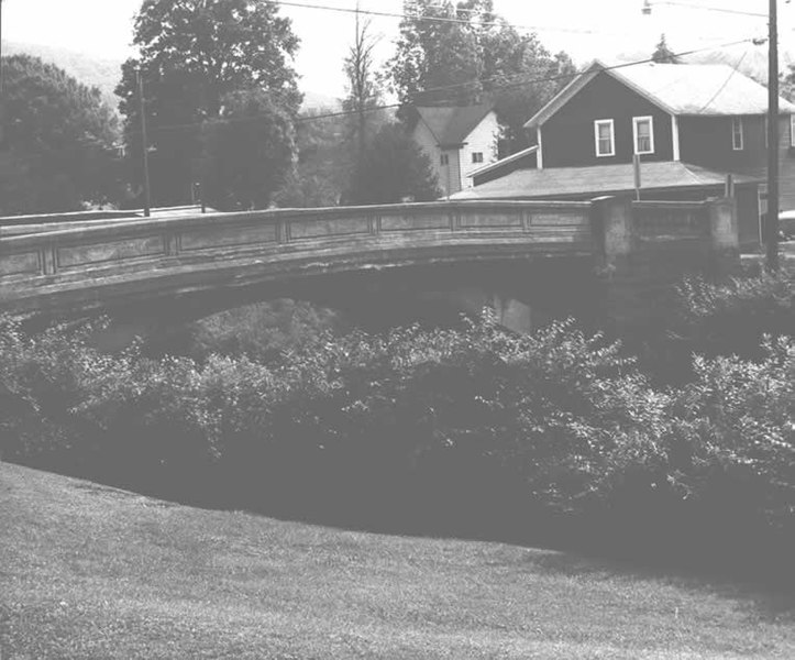
English: Side of the Bridge in Westover Borough, which carries Legislative Route 17003/Township Route 185 over Chest Creek in Westover, Pennsylvania, United States. Built in 1917, this open spandrel concrete arch bridge is listed on the National Register of Historic Places. |
|||
| Data | ||||
| Funtana | "Bridge in Westover Borough" (National Register of Historic Places form). National Park Service (June 22, 1988). Photo from http://www.arch.state.pa.us, searchable database, at http://www.arch.state.pa.us/images/hires/H000121_01B.jpg | |||
| Autur | PennDOT | |||
| Lizënza (Tó ca danü chësc file) |
|

Storia dl documënt
Druca sun na data/ëura per udëi l documënt coche l fo te chël mumënt.
| Data/Ëura | Miniatura | Grandëza | utënt | Cumentar | |
|---|---|---|---|---|---|
| atuel | 06:10, 21 dez 2009 | | 764 × 634 (46 KB) | Nyttend | {{Location|40|45|9|N|78|40|3|W}} {{Information |Description={{en|Side of the {{w|Bridge in Westover Borough}}, which carries Legislative Route 17003/Township Route 185 over {{w|Chest Creek}} in {{w|Westover, Pennsylvania|Westover}}, {{w|Pennsylvania}}, {{ |
Coche l document ie stat adurvà
Chësta plata adroa chësc documënt:
Coche l documënt ie stat adurvà ntëur l mond
Ënghe chësta wikis adroa chësc documënt:
- Adurvà sun ar.wikipedia.org
- Adurvà sun azb.wikipedia.org
- Adurvà sun ca.wikipedia.org
- Adurvà sun ceb.wikipedia.org
- Adurvà sun ce.wikipedia.org
- Adurvà sun cy.wikipedia.org
- Adurvà sun en.wikipedia.org
- Adurvà sun es.wikipedia.org
- Adurvà sun eu.wikipedia.org
- Adurvà sun fr.wikipedia.org
- Adurvà sun ht.wikipedia.org
- Adurvà sun it.wikipedia.org
- Adurvà sun pt.wikipedia.org
- Adurvà sun sr.wikipedia.org
- Adurvà sun tl.wikipedia.org
- Adurvà sun tt.wikipedia.org
- Adurvà sun uk.wikipedia.org
- Adurvà sun uz.wikipedia.org
- Adurvà sun vi.wikipedia.org
- Adurvà sun www.wikidata.org
- Adurvà sun zh-min-nan.wikipedia.org