
File:Charcot Island, Antarctica.png
Dimenjiuns de chësta odüda danfora:697 x 600 pixel. Autra resoluzions: 279 x 240 pixel | 558 x 480 pixel | 925 x 796 pixel.
Documënt uriginel (925 × 796 pixels, dimenjiun dl file: 441 KB, MIME type: image/png)
Ressumé
| Descriziun |
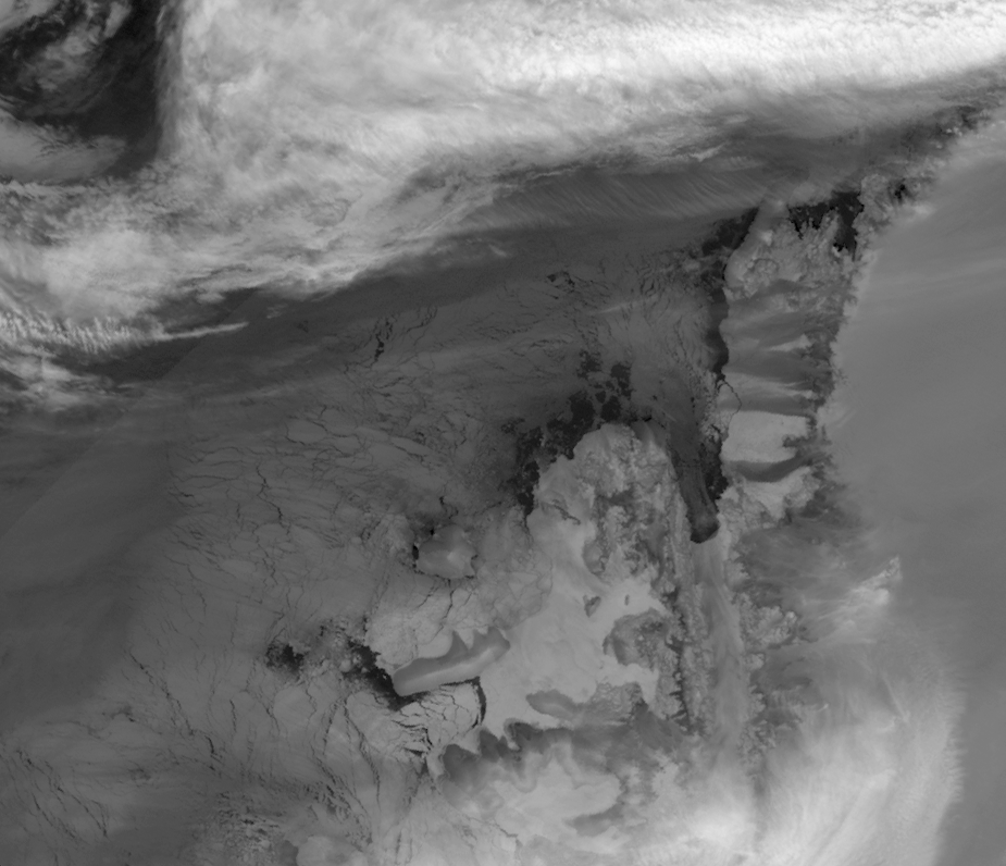
English: This image is made from thermal infra-red data collected by the Moderate Resolution Imaging Spectroradiometer (MODIS) on NASA’s Terra satellite. (A photo-like image isn’t possible at this latitude in the winter because of polar darkness). This greyscale image shows relative differences in surface temperature. Dark grey indicates relatively warm temperatures and white indicates relatively cold temperatures. Remnant ice shelf east of Latady Island appears white, as does some of the sea ice between Charcot and Latady Islands. Charcot Island’s nearly black perimeter indicates an area of relatively open ocean that could be navigated by ship. In addition, an area of relatively warm ocean water appears off the western end of Latady Island. |
| Data | |
| Funtana | NASA Earth Observatory |
| Autur | Jesse Allen |
Data obtained from the Goddard Level 1 and Atmospheric Archive and Distribution System (LAADS). Image interpretation by Ted Scambos, National Snow and Ice Data Centre. Instrument: Terra - MODIS.
Lizënza
| Questo file è nel pubblico dominio perché creato dalla NASA. La politica sul copyright della NASA afferma che «il materiale della NASA non è protetto da copyright a meno che non sia specificato altrimenti». (NASA copyright policy e JPL Image Use Policy). | ||
 |
Attenzione:
|
Storia dl documënt
Druca sun na data/ëura per udëi l documënt coche l fo te chël mumënt.
| Data/Ëura | Miniatura | Grandëza | utënt | Cumentar | |
|---|---|---|---|---|---|
| atuel | 11:02, 14 ago 2009 | | 925 × 796 (441 KB) | Originalwana | {{Information |Description={{en|1=This image is made from thermal infra-red data collected by the Moderate Resolution Imaging Spectroradiometer (MODIS) on NASA’s Terra satellite. (A photo-like image isn’t possible at this latitude in the winter becaus |
Coche l document ie stat adurvà
Chësta plata adroa chësc documënt:
Coche l documënt ie stat adurvà ntëur l mond
Ënghe chësta wikis adroa chësc documënt:
- Adurvà sun ceb.wikipedia.org
- Adurvà sun en.wikipedia.org
- Adurvà sun es.wikipedia.org
- Adurvà sun he.wikipedia.org
- Adurvà sun it.wikipedia.org
- Adurvà sun ja.wikipedia.org
- Adurvà sun nn.wikipedia.org
- Adurvà sun sv.wikipedia.org
- Adurvà sun www.wikidata.org
- Adurvà sun zh.wikipedia.org