
File:Corinne Methodist Episcopal Church.jpg

Dimenjiuns de chësta odüda danfora:474 x 600 pixel. Autra resoluzions: 190 x 240 pixel | 379 x 480 pixel | 607 x 768 pixel | 809 x 1 024 pixel | 1 618 x 2 048 pixel | 3 584 x 4 535 pixel.
Documënt uriginel (3 584 × 4 535 pixels, dimenjiun dl file: 1,7 MB, MIME type: image/jpeg)
| Luogo dello scatto | | Posizione di questa e altre immagini su: OpenStreetMap |
|---|
| Descriziun |
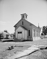
English: Front of the Corinne Methodist Episcopal Church, located at the intersection of Coronado and South 600 Streets in Corinne, Utah, United States. Built in 1870, it is listed on the National Register of Historic Places. |
|||||
| Data | ||||||
| Funtana | Library of Congress, Prints and Photograph Division HABS: UTAH,2-CORI,1-2 | |||||
| Autur | P. Kent Fairbanks | |||||
| Lizënza (Tó ca danü chësc file) |
|


|
Questa image è disponibile presso la Divisione Stampe e Fotografie (Prints and Photographs Division) della Biblioteca del Congresso sotto l'ID digitale hhh.ut0007.
Questo tag non indica lo status del copyright dell'opera ad esso associato. È quindi richiesto un normale tag di copyright. Vedi Commons:Licenze per maggiori informazioni.
|
Storia dl documënt
Druca sun na data/ëura per udëi l documënt coche l fo te chël mumënt.
| Data/Ëura | Miniatura | Grandëza | utënt | Cumentar | |
|---|---|---|---|---|---|
| atuel | 10:50, 23 mei 2009 | | 3 584 × 4 535 (1,7 MB) | Cropbot | upload cropped version, operated by User:Finavon. Summary: border cropped |
| 07:10, 23 mei 2009 |  | 4 038 × 4 993 (1,94 MB) | Nyttend | {{Location|41|32|51|N|112|6|40|W}} {{Information |Description={{en|Front of the {{w|Corinne Methodist Episcopal Church}}, located at the intersection of Coronado and South 600 Streets in {{w|Corinne, Utah|Corinne}}, {{w|Utah}}, {{w|United States}}. Built |
Coche l document ie stat adurvà
Chësta plata adroa chësc documënt:
Coche l documënt ie stat adurvà ntëur l mond
Ënghe chësta wikis adroa chësc documënt:
- Adurvà sun ar.wikipedia.org
- Adurvà sun arz.wikipedia.org
- Adurvà sun azb.wikipedia.org
- Adurvà sun bg.wikipedia.org
- Adurvà sun ca.wikipedia.org
- Adurvà sun ceb.wikipedia.org
- Adurvà sun ce.wikipedia.org
- Adurvà sun cy.wikipedia.org
- Adurvà sun en.wikipedia.org
- Adurvà sun eu.wikipedia.org
- Adurvà sun fa.wikipedia.org
- Adurvà sun fr.wikipedia.org
- Adurvà sun ht.wikipedia.org
- Adurvà sun it.wikipedia.org
- Adurvà sun pl.wikipedia.org
- Adurvà sun pt.wikipedia.org
- Adurvà sun sh.wikipedia.org
- Adurvà sun sr.wikipedia.org
- Adurvà sun tt.wikipedia.org
- Adurvà sun uk.wikipedia.org
- Adurvà sun uz.wikipedia.org
- Adurvà sun www.wikidata.org
- Adurvà sun zh-min-nan.wikipedia.org