
File:Crags on summit of Mynydd Graig Goch - geograph.org.uk - 196667.jpg
Degöna resoluziun plü alta desponibla.
Crags_on_summit_of_Mynydd_Graig_Goch_-_geograph.org.uk_-_196667.jpg (640 × 480 pixels, dimenjiun dl file: 138 KB, MIME type: image/jpeg)
Ressumé
| Descriziun |
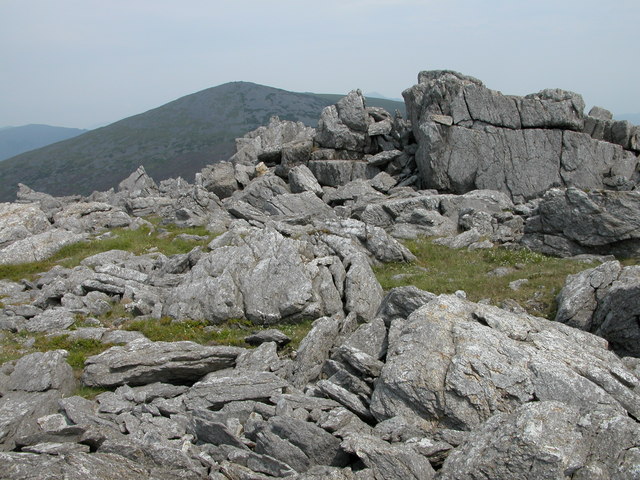
English: Crags on summit of Mynydd Graig Goch. Mynydd Graig Goch is situated at the western end of the Nantlle Ridge, though many walkers do not venture beyond Garnedd-goch which can be seen in the background. The summit of Snowdon is just visible between the rocky crags.
In September 2008, this summit made national news after three walkers surveyed it after suspecting it was really just over 2000 feet and therefore officially classified as a mountain. Their survey has been recognised by Ordnance Survey thus bringing the total of mountains in Wales to 190. Maybe now it has been elevated to mountain status it will attract more walkers to its rocky summit. See: https://www.telegraph.co.uk/news/newstopics/politics/wales/2989936/Wales-acquires-a-new-mountain-but-loses-a-hill.html |
| Data | |
| Funtana | From geograph.org.uk |
| Autur | Philip Halling |
| Atribuzion (richiesto dalla licenza) | Philip Halling / Crags on summit of Mynydd Graig Goch / |
| Luogo dello scatto | | Posizione di questa e altre immagini su: OpenStreetMap |
|---|
_heading:45.00&language=lld)
| Posizione del soggetto | | Posizione di questa e altre immagini su: OpenStreetMap |
|---|
_heading:45.00&language=lld)
Lizënza

|
Questa immagine proviene dalla collezione del progetto Geograph. Vedi questa fotografia sul sito web di Geograph per visualizzare i dettagli relativi al fotografo. Il copyright di questa immagine appartiene a Philip Halling ed è pubblicata secondo i termini della licenza Creative Commons Attribuzione-Condividi allo stesso modo 2.0.
|
Questo file è disponibile in base alla licenza Creative Commons Attribuzione-Condividi allo stesso modo 2.0 Generico
Atribuzion: Philip Halling
- Tu ies liede:
- da spartì – per cupié, spartësc y manda l lëur
- da mudé – da adaté al lëur
- A chësta condizions:
- atribuzion – Tu mues atribué l lëur te la maniera che à spiegà l autëur o chël che à la lizënza (ma nia te na maniera che l smea che ëi te paiessa).
- fá na condivijiun tla medema manira – Sce te mudes o svilupeies chësc test, pudres mé spartì ora l lëur sota la medema lizënza o una che ti smea a chësta same or compatible license
Storia dl documënt
Druca sun na data/ëura per udëi l documënt coche l fo te chël mumënt.
| Data/Ëura | Miniatura | Grandëza | utënt | Cumentar | |
|---|---|---|---|---|---|
| atuel | 17:38, 31 jen 2010 | | 640 × 480 (138 KB) | GeographBot | == {{int:filedesc}} == {{Information |description={{en|1=Crags on summit of Mynydd Graig Goch. Mynydd Graig Goch is situated at the western end of the Nantlle Ridge, though many walkers do not venture beyond Garnedd-goch which can be seen in the backgroun |
Coche l document ie stat adurvà
Chësta plata adroa chësc documënt:
Coche l documënt ie stat adurvà ntëur l mond
Ënghe chësta wikis adroa chësc documënt:
- Adurvà sun arz.wikipedia.org
- Adurvà sun ceb.wikipedia.org
- Adurvà sun cy.wikipedia.org
- Adurvà sun en.wikipedia.org
- Adurvà sun sv.wikipedia.org
- Adurvà sun www.wikidata.org