
File:Dean Architects - fmr Railway Branch YMCA - Depew, New York - 20210219.jpg

Dimenjiuns de chësta odüda danfora:800 x 599 pixel. Autra resoluzions: 320 x 240 pixel | 640 x 480 pixel | 1 024 x 767 pixel | 1 280 x 959 pixel | 1 791 x 1 342 pixel.
Documënt uriginel (1 791 × 1 342 pixels, dimenjiun dl file: 833 KB, MIME type: image/jpeg)
Ressumé
| Descriziun |
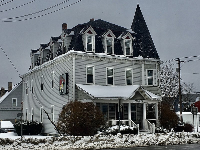
English: Dean Architects, 3284 Walden Avenue at Tyler Street, Depew, New York, February 2021. Erected in 1896 as one of the first batch of institutional buildings built by the Depew Improvement Company for the then-newly founded village, this serves as an anachronistic example of the Second Empire architectural style with its bracketed cornice, pedimented dormer windows framed by stylized columns, and of course, proud mansard roof. However, the shingle-sided, tent-roofed corner turret and the asymmetrical front porch with its off-center pediment both borrow from the Queen Anne style, which was much less passé at the time. The building functioned initially as the so-called Railroad Branch YMCA, which appears to have been defunct by 1912: a Depew Herald article from that year mentions a proposal to move the "former Y.M.C.A. building" to nearby Transit Road and convert it to a hotel, which apparently never materialized as the building remains on its original site. By 1939 it was in use as apartments, initially with a modest but respectable lower-middle-class tenant base composed mainly of workers at the machine shops and factories gathered around the New York Central Railroad line; the village's raison d'être. By the 1980s it had degenerated into a sleazy and dilapidated rooming house, and it was slated for demolition by 1998, when DeanSutton Architecture purchased the building and fully restored it for use as their offices. Dean Architects, the successor firm, remains headquartered there today. |
| Data | Scattata il 19 fauré 2021, 10:43:48 |
| Funtana | Opera personala |
| Autur | Andre Carrotflower |
| Luogo dello scatto | | Posizione di questa e altre immagini su: OpenStreetMap |
|---|
Lizënza
Io, detentore del copyright su quest'opera, dichiaro di pubblicarla con la seguente licenza:
Questo file è disponibile in base alla licenza Creative Commons Attribuzione-Condividi allo stesso modo 4.0 Internazionale
- Tu ies liede:
- da spartì – per cupié, spartësc y manda l lëur
- da mudé – da adaté al lëur
- A chësta condizions:
- atribuzion – Tu mues atribué l lëur te la maniera che à spiegà l autëur o chël che à la lizënza (ma nia te na maniera che l smea che ëi te paiessa).
- fá na condivijiun tla medema manira – Sce te mudes o svilupeies chësc test, pudres mé spartì ora l lëur sota la medema lizënza o una che ti smea a chësta same or compatible license
Storia dl documënt
Druca sun na data/ëura per udëi l documënt coche l fo te chël mumënt.
| Data/Ëura | Miniatura | Grandëza | utënt | Cumentar | |
|---|---|---|---|---|---|
| atuel | 05:34, 25 aur 2021 | | 1 791 × 1 342 (833 KB) | Andre Carrotflower | Uploaded own work with UploadWizard |
Coche l document ie stat adurvà
Chësta plata adroa chësc documënt:
Coche l documënt ie stat adurvà ntëur l mond
Ënghe chësta wikis adroa chësc documënt:
- Adurvà sun ar.wikipedia.org
- Adurvà sun ca.wikipedia.org
- Adurvà sun ceb.wikipedia.org
- Adurvà sun cy.wikipedia.org
- Adurvà sun es.wikipedia.org
- Adurvà sun eu.wikipedia.org
- Adurvà sun fr.wikipedia.org
- Adurvà sun ht.wikipedia.org
- Adurvà sun hu.wikipedia.org
- Adurvà sun it.wikipedia.org
- Adurvà sun pl.wikipedia.org
- Adurvà sun sr.wikipedia.org
- Adurvà sun uk.wikipedia.org
- Adurvà sun www.wikidata.org