
File:Ennstal.jpg

Dimenjiuns de chësta odüda danfora:448 x 600 pixel. Autra resoluzions: 179 x 240 pixel | 358 x 480 pixel | 573 x 768 pixel | 1 120 x 1 500 pixel.
Documënt uriginel (1 120 × 1 500 pixels, dimenjiun dl file: 260 KB, MIME type: image/jpeg)
Ressumé
| Descriziun |
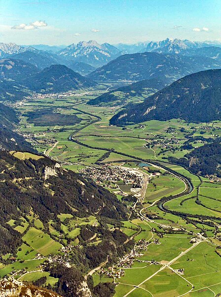
Deutsch: Oberes Ennstal zwischen Stainach und Liezen in der Steiermark, vom Grimming aus gesehen, Blickrichtung Osten, gegen das Gesäuse:
English: Valley of the Enns River (“Ennstal”), between the towns of Stainach (below centre) and Liezen (farther back, upper third), seen from the summit of Mt. Grimming, viewing direction is to the east. In the background the tops of the two rocky (limestone) ridges flanking the Gesäuse canyon, cut by the Enns River further downstream, are visible. |
| Data | |
| Funtana | Own photo, slightly manipulated to reduce haze |
| Autur | User:Stemonitis |
| Lizënza (Tó ca danü chësc file) |
CC Attribution ShareAlike 2.5 |
| Luogo dello scatto | | Posizione di questa e altre immagini su: OpenStreetMap |
|---|
Lizënza
Questo file è disponibile in base alla licenza Creative Commons Attribuzione-Condividi allo stesso modo 2.5 Generico
- Tu ies liede:
- da spartì – per cupié, spartësc y manda l lëur
- da mudé – da adaté al lëur
- A chësta condizions:
- atribuzion – Tu mues atribué l lëur te la maniera che à spiegà l autëur o chël che à la lizënza (ma nia te na maniera che l smea che ëi te paiessa).
- fá na condivijiun tla medema manira – Sce te mudes o svilupeies chësc test, pudres mé spartì ora l lëur sota la medema lizënza o una che ti smea a chësta same or compatible license
| Annotations | This image is annotated: View the annotations at Commons |
Storia dl documënt
Druca sun na data/ëura per udëi l documënt coche l fo te chël mumënt.
| Data/Ëura | Miniatura | Grandëza | utënt | Cumentar | |
|---|---|---|---|---|---|
| atuel | 13:57, 23 nuë 2023 | | 1 120 × 1 500 (260 KB) | Martin Geisler | heller, Dunstentfernung |
| 16:07, 4 sët 2006 |  | 1 120 × 1 500 (160 KB) | Stemonitis | {{Information |Description=Ennstal, between Stainach (below centre) and Liezen (towards the background), seen from the summit of Grimming. On the horizon, the two ridges of the Gesäuse can be seen, one on either side of the River Enns. |Source=Own photo, |
Coche l document ie stat adurvà
Chësta plata adroa chësc documënt:
Coche l documënt ie stat adurvà ntëur l mond
Ënghe chësta wikis adroa chësc documënt:
- Adurvà sun ar.wikipedia.org
- Adurvà sun arz.wikipedia.org
- Adurvà sun azb.wikipedia.org
- Adurvà sun ba.wikipedia.org
- Adurvà sun be.wikipedia.org
- Adurvà sun bg.wikipedia.org
- Adurvà sun bn.wikipedia.org
- Adurvà sun ca.wikipedia.org
- Adurvà sun ceb.wikipedia.org
- Adurvà sun cs.wikipedia.org
- Adurvà sun cv.wikipedia.org
- Adurvà sun da.wikipedia.org
- Adurvà sun de.wikipedia.org
- Adurvà sun el.wikipedia.org
- Adurvà sun en.wikipedia.org
- Adurvà sun eo.wikipedia.org
- Adurvà sun es.wikipedia.org
- Adurvà sun et.wikipedia.org
- Adurvà sun eu.wikipedia.org
- Adurvà sun fa.wikipedia.org
- Adurvà sun fi.wikipedia.org
- Adurvà sun fr.wikipedia.org
- Adurvà sun hu.wikipedia.org
- Adurvà sun hy.wikipedia.org
- Adurvà sun id.wikipedia.org
- Adurvà sun it.wikipedia.org
- Adurvà sun ka.wikipedia.org
- Adurvà sun ko.wikipedia.org
- Adurvà sun ku.wikipedia.org
- Adurvà sun lt.wikipedia.org
- Adurvà sun lv.wikipedia.org
- Adurvà sun nl.wikipedia.org
- Adurvà sun nn.wikipedia.org
- Adurvà sun no.wikipedia.org
- Adurvà sun pl.wikipedia.org
- Adurvà sun pt.wikipedia.org
- Adurvà sun ro.wikipedia.org
- Adurvà sun ru.wikipedia.org
- Adurvà sun sk.wikipedia.org
Mostra utilisaziun globala de chësc file.