
File:Grimsby Dock Tower.jpg
Documënt uriginel (523 × 640 pixels, dimenjiun dl file: 99 KB, MIME type: image/jpeg)
Ressumé
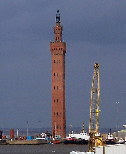
This is a photo of listed building number 1379870. |
| Luogo dello scatto | | Posizione di questa e altre immagini su: OpenStreetMap |
|---|
| Posizione del soggetto | | Posizione di questa e altre immagini su: OpenStreetMap |
|---|
_region:GB-GBN_heading:22.00&language=lld)
| Descriziun |
Grimsby Dock Tower Note that the Grimsby tower isn't a hydraulic accumulator (it's in the category because it's an important part of their history). Towers such as Grimsby achieved high pressures simply by their height, expensive though these were to construct. It was soon realised that a pressurised cistern with a heavy iron or concrete weight on it gave the same results, at much less cost.
For more information on the tower see Link |
| Data | |
| Funtana | Geograph |
| Autur | David Wright (Uploaded by User:PeterJewell) |
| Lizënza (Tó ca danü chësc file) |
Creative Commons: Attribution-ShareAlike 2.0 |
Lizënza

|
Questa immagine proviene dalla collezione del progetto Geograph. Vedi questa fotografia sul sito web di Geograph per visualizzare i dettagli relativi al fotografo. Il copyright di questa immagine appartiene a David Wright ed è pubblicata secondo i termini della licenza Creative Commons Attribuzione-Condividi allo stesso modo 2.0.
|
- Tu ies liede:
- da spartì – per cupié, spartësc y manda l lëur
- da mudé – da adaté al lëur
- A chësta condizions:
- atribuzion – Tu mues atribué l lëur te la maniera che à spiegà l autëur o chël che à la lizënza (ma nia te na maniera che l smea che ëi te paiessa).
- fá na condivijiun tla medema manira – Sce te mudes o svilupeies chësc test, pudres mé spartì ora l lëur sota la medema lizënza o una che ti smea a chësta same or compatible license
Storia dl documënt
Druca sun na data/ëura per udëi l documënt coche l fo te chël mumënt.
| Data/Ëura | Miniatura | Grandëza | utënt | Cumentar | |
|---|---|---|---|---|---|
| atuel | 02:41, 17 lug 2007 | | 523 × 640 (99 KB) | PeterJewell | {{Information |Description= |Source= |Date= |Author= |Permission= |other_versions= }} |
Coche l document ie stat adurvà
Chësta plata adroa chësc documënt:
Coche l documënt ie stat adurvà ntëur l mond
Ënghe chësta wikis adroa chësc documënt:
- Adurvà sun ar.wikipedia.org
- Adurvà sun arz.wikipedia.org
- Adurvà sun azb.wikipedia.org
- Adurvà sun be.wikipedia.org
- Adurvà sun ca.wikipedia.org
- Adurvà sun ceb.wikipedia.org
- Adurvà sun cy.wikipedia.org
- Adurvà sun da.wikipedia.org
- Adurvà sun de.wikipedia.org
- Adurvà sun de.wikivoyage.org
- Adurvà sun en.wikipedia.org
- Adurvà sun en.wikivoyage.org
- Adurvà sun eo.wikipedia.org
- Adurvà sun es.wikipedia.org
- Adurvà sun eu.wikipedia.org
- Adurvà sun fa.wikipedia.org
- Adurvà sun fi.wikipedia.org
- Adurvà sun frr.wikipedia.org
- Adurvà sun fr.wikipedia.org
- Adurvà sun ga.wikipedia.org
- Adurvà sun he.wikipedia.org
- Adurvà sun id.wikipedia.org
- Adurvà sun it.wikipedia.org
- Adurvà sun it.wikivoyage.org
- Adurvà sun ko.wikipedia.org
- Adurvà sun lt.wikipedia.org
- Adurvà sun nl.wikipedia.org
- Adurvà sun nn.wikipedia.org
- Adurvà sun no.wikipedia.org
- Adurvà sun ro.wikipedia.org
- Adurvà sun ru.wikipedia.org
- Adurvà sun simple.wikipedia.org
- Adurvà sun sr.wikipedia.org
- Adurvà sun sv.wikipedia.org
- Adurvà sun tt.wikipedia.org
- Adurvà sun uk.wikipedia.org
- Adurvà sun ur.wikipedia.org
- Adurvà sun www.wikidata.org
- Adurvà sun zh.wikipedia.org