
File:High Street, Bramley opposite the Library - geograph.org.uk - 527410.jpg
Degöna resoluziun plü alta desponibla.
High_Street,_Bramley_opposite_the_Library_-_geograph.org.uk_-_527410.jpg (640 × 519 pixels, dimenjiun dl file: 127 KB, MIME type: image/jpeg)
Ressumé
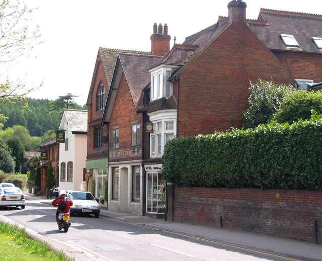
| Descriziun |
English: High Street, Bramley opposite the Library The tall Victorian building is the site of the Bramley Brewery, owned by the Smith family. Beer was brewed on this site from 1865 by William Smith. In 1901 his son Morton Smith was listed on the census as brewer and jeweller. In 1904 it was bought by Brufords of Cranleigh and in 1917 it was taken over by Cobham United Breweries.
Further down, still visible in the photo, was the Foundry also owned by the Smith family. Charles Smith, William's father bought the foundry in 1847. |
| Data | |
| Funtana | From geograph.org.uk |
| Autur | Clare |
| Atribuzion (richiesto dalla licenza) | Clare / High Street, Bramley opposite the Library / |
| Luogo dello scatto | | Posizione di questa e altre immagini su: OpenStreetMap |
|---|
_heading:180.00&language=lld)
| Posizione del soggetto | | Posizione di questa e altre immagini su: OpenStreetMap |
|---|
_heading:180.00&language=lld)
Lizënza

|
Questa immagine proviene dalla collezione del progetto Geograph. Vedi questa fotografia sul sito web di Geograph per visualizzare i dettagli relativi al fotografo. Il copyright di questa immagine appartiene a Clare ed è pubblicata secondo i termini della licenza Creative Commons Attribuzione-Condividi allo stesso modo 2.0.
|
Questo file è disponibile in base alla licenza Creative Commons Attribuzione-Condividi allo stesso modo 2.0 Generico
Atribuzion: Clare
- Tu ies liede:
- da spartì – per cupié, spartësc y manda l lëur
- da mudé – da adaté al lëur
- A chësta condizions:
- atribuzion – Tu mues atribué l lëur te la maniera che à spiegà l autëur o chël che à la lizënza (ma nia te na maniera che l smea che ëi te paiessa).
- fá na condivijiun tla medema manira – Sce te mudes o svilupeies chësc test, pudres mé spartì ora l lëur sota la medema lizënza o una che ti smea a chësta same or compatible license
Storia dl documënt
Druca sun na data/ëura per udëi l documënt coche l fo te chël mumënt.
| Data/Ëura | Miniatura | Grandëza | utënt | Cumentar | |
|---|---|---|---|---|---|
| atuel | 18:28, 5 fau 2011 | | 640 × 519 (127 KB) | GeographBot | == {{int:filedesc}} == {{Information |description={{en|1=High Street, Bramley opposite the Library The tall Victorian building is the site of the Bramley Brewery, owned by the Smith family. Beer was brewed on this site from 1865 by William Smith. In 1901 |
Coche l document ie stat adurvà
Chësta plata adroa chësc documënt:
Coche l documënt ie stat adurvà ntëur l mond
Ënghe chësta wikis adroa chësc documënt:
- Adurvà sun azb.wikipedia.org
- Adurvà sun ceb.wikipedia.org
- Adurvà sun cy.wikipedia.org
- Adurvà sun en.wikipedia.org
- Adurvà sun es.wikipedia.org
- Adurvà sun fa.wikipedia.org
- Adurvà sun fr.wikipedia.org
- Adurvà sun id.wikipedia.org
- Adurvà sun no.wikipedia.org
- Adurvà sun pl.wikipedia.org
- Adurvà sun www.wikidata.org
- Adurvà sun zh-min-nan.wikipedia.org