
File:Kirkby Town Centre - geograph.org.uk - 122465.jpg
Degöna resoluziun plü alta desponibla.
Kirkby_Town_Centre_-_geograph.org.uk_-_122465.jpg (640 × 480 pixels, dimenjiun dl file: 60 KB, MIME type: image/jpeg)
Ressumé
| Descriziun |
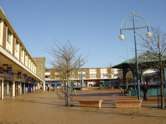
English: Kirkby centre. Looking north from Newtown Gardens.
The "Newtown" (remember Z cars?) of Kirkby owes its being to the closure of the Royal Ordnance Factory in 1946 when the Government suggested to Liverpool City Council that making use of some of the thousand buildings and creating a large trading/industrial estate would provide jobs for redundant workers and the demobbed. The trading estate steadily expanded through the 1950s and 1960s to become one of the largest in the country, at its peak in 1971, the estate employed over 26,000 people. A model town of 10,000 houses was constructed, mainly as an overspill for Liverpool, on what was once agricultural land and the modest population of 3,000 expanded to 50,000 by 1961. New facilities to cater for the growing population included a variety of shops, banks and business premises, a library and a market, probably the only surviving outdoor market on Merseyside. |
| Data | |
| Funtana | From geograph.org.uk |
| Autur | Sue Adair |
| Atribuzion (richiesto dalla licenza) | Sue Adair / Kirkby Town Centre / |
| Posizione del soggetto | | Posizione di questa e altre immagini su: OpenStreetMap |
|---|
_&language=lld)
Lizënza

|
Questa immagine proviene dalla collezione del progetto Geograph. Vedi questa fotografia sul sito web di Geograph per visualizzare i dettagli relativi al fotografo. Il copyright di questa immagine appartiene a Sue Adair ed è pubblicata secondo i termini della licenza Creative Commons Attribuzione-Condividi allo stesso modo 2.0.
|
Questo file è disponibile in base alla licenza Creative Commons Attribuzione-Condividi allo stesso modo 2.0 Generico
Atribuzion: Sue Adair
- Tu ies liede:
- da spartì – per cupié, spartësc y manda l lëur
- da mudé – da adaté al lëur
- A chësta condizions:
- atribuzion – Tu mues atribué l lëur te la maniera che à spiegà l autëur o chël che à la lizënza (ma nia te na maniera che l smea che ëi te paiessa).
- fá na condivijiun tla medema manira – Sce te mudes o svilupeies chësc test, pudres mé spartì ora l lëur sota la medema lizënza o una che ti smea a chësta same or compatible license
- Remove redundant categories and try to put this image in the most specific category/categories
- Remove this template
- The location categories are based on information from this geonames tool and this OpenStreetMap tool combined with a database. You can also have a look at this tool from mysociety.
- The topic category from Geograph was Kirkby centre (find similar images centre at Geograph)
Storia dl documënt
Druca sun na data/ëura per udëi l documënt coche l fo te chël mumënt.
| Data/Ëura | Miniatura | Grandëza | utënt | Cumentar | |
|---|---|---|---|---|---|
| atuel | 05:31, 31 jen 2010 | | 640 × 480 (60 KB) | GeographBot | == {{int:filedesc}} == {{Information |description={{en|1=Kirkby Town Centre. Looking north from Newtown Gardens to Kirkby town centre. The "Newtown" (remember Z cars?) of Kirkby owes its being to the closure of the Royal Ordnance Factory in 1946 when the |
Coche l document ie stat adurvà
Chësta plata adroa chësc documënt:
Coche l documënt ie stat adurvà ntëur l mond
Ënghe chësta wikis adroa chësc documënt:
- Adurvà sun ar.wikipedia.org
- Adurvà sun be.wikipedia.org
- Adurvà sun ceb.wikipedia.org
- Adurvà sun cy.wikipedia.org
- Adurvà sun de.wikipedia.org
- Adurvà sun en.wikipedia.org
- Adurvà sun es.wikipedia.org
- Adurvà sun it.wikipedia.org
- Adurvà sun pl.wikipedia.org
- Adurvà sun ro.wikipedia.org
- Adurvà sun ru.wikipedia.org
- Adurvà sun sv.wikipedia.org
- Adurvà sun www.wikidata.org