
File:Mt Harun from Taybe.JPG
Dimenjiuns de chësta odüda danfora:800 x 446 pixel. Autra resoluzions: 320 x 178 pixel | 640 x 356 pixel | 1 024 x 570 pixel | 1 600 x 891 pixel.
Documënt uriginel (1 600 × 891 pixels, dimenjiun dl file: 301 KB, MIME type: image/jpeg)
Ressumé
| Descriziun |
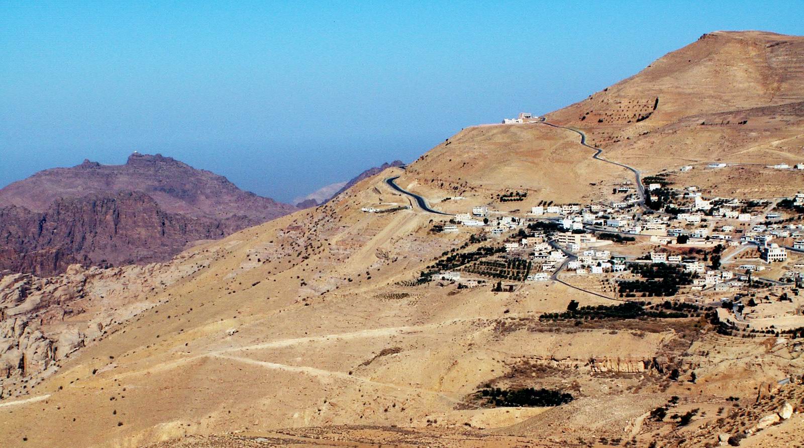
Jebel Harun (mt. of Aaron) at the left as seen from the Village of Taybe, south of Petra. the top of Jebel Harun has two peaks. on the right peak is the "Welly", The mosque on the grave of Aaron. in the photo it can be seen as a white dot on the top. Jebel Harun is part of Petra archeological site. Jebel Harun is located in the Horeb mountains, The red rocks area of Petra. high above the Horeb mountains is Mt. Seir or jebel A-Shara, where the village of Taybe is located and many other small villages. Photo by Uri Juda |
| Data | 14 jené 2006 (data di caricamento originaria) |
| Funtana | No machine-readable source provided. Own work assumed (based on copyright claims). |
| Autur | No machine-readable author provided. Uri~commonswiki assumed (based on copyright claims). |
Lizënza
Io, detentore del copyright su quest'opera, dichiaro di pubblicarla con le seguenti licenze:

|
AL é la lizënza da copié, da dé inant y/o müdé chësc documënt aladô dla lizënza GNU Free Documentation License, Verjiun 1.2 o vigni atra verjiun suandënta publicada dala Free Software Foundation; zënza seziuns che ara ne vá nia da mudé, zënza test söl cuertl ca dant y do ia. Na copia dla lizënza é tla seziun cun le titul Test dla GNU Free Documentation License. |
| Chësc file á la lizënza de destribuziun aladô dla lizënza Creative Commons Attribution-Share Alike 3.0 Unported. | ||
| ||
| Questo tag di copyright è stato aggiunto nell'ambito dell'aggiornamento della licenza dei progetti Wikimedia. |
Questo file è disponibile in base alle licenze Creative Commons Attribuzione-Condividi allo stesso modo 2.5 Generico, 2.0 Generico e 1.0 Generico
- Tu ies liede:
- da spartì – per cupié, spartësc y manda l lëur
- da mudé – da adaté al lëur
- A chësta condizions:
- atribuzion – Tu mues atribué l lëur te la maniera che à spiegà l autëur o chël che à la lizënza (ma nia te na maniera che l smea che ëi te paiessa).
- fá na condivijiun tla medema manira – Sce te mudes o svilupeies chësc test, pudres mé spartì ora l lëur sota la medema lizënza o una che ti smea a chësta same or compatible license
Pos chirí fora la lizënza che as plü ion
Storia dl documënt
Druca sun na data/ëura per udëi l documënt coche l fo te chël mumënt.
| Data/Ëura | Miniatura | Grandëza | utënt | Cumentar | |
|---|---|---|---|---|---|
| atuel | 01:18, 15 jen 2006 | | 1 600 × 891 (301 KB) | Uri~commonswiki | Jebel Harun (mt. of Aaron) at the left as seen from the Vilage of Taybe, south of Petra. Mt. Harun is located in the Horeb mountains, The red rocks area of Petra. high above the Horeb mountains is Mt. Seir or jebel A-Shara where we can see the village of |
Coche l document ie stat adurvà
Chësta plata adroa chësc documënt:
Coche l documënt ie stat adurvà ntëur l mond
Ënghe chësta wikis adroa chësc documënt:
- Adurvà sun ar.wikipedia.org
- Adurvà sun arz.wikipedia.org
- Adurvà sun bn.wikipedia.org
- Adurvà sun cy.wikipedia.org
- Adurvà sun en.wikipedia.org
- Adurvà sun es.wikipedia.org
- Adurvà sun fi.wikipedia.org
- Adurvà sun fr.wikipedia.org
- Adurvà sun he.wikipedia.org
- Adurvà sun hy.wikipedia.org
- Adurvà sun id.wikipedia.org
- Adurvà sun lt.wikipedia.org
- Adurvà sun nn.wikipedia.org
- Adurvà sun ro.wikipedia.org
- Adurvà sun ru.wikipedia.org
- Adurvà sun sco.wikipedia.org
- Adurvà sun sl.wikipedia.org
- Adurvà sun ta.wikipedia.org
- Adurvà sun uk.wikipedia.org
- Adurvà sun www.wikidata.org
- Adurvà sun zh.wikipedia.org