
File:New sign marking the eastern boundary of Haigh - geograph.org.uk - 1045584.jpg
Degöna resoluziun plü alta desponibla.
New_sign_marking_the_eastern_boundary_of_Haigh_-_geograph.org.uk_-_1045584.jpg (640 × 426 pixels, dimenjiun dl file: 59 KB, MIME type: image/jpeg)
Ressumé
| Descriziun |
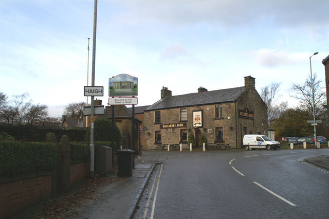
English: New sign marking the eastern boundary of Haigh This type of pictorial sign is being erected around Wigan Borough, largely at the request of local people, to mark the many separate communities, often old mining villages originally, which make up the modern Metropolitan Borough. The design is also often chosen after local consultation. Some show more imagination than others. Many share a common fault - the posts to which they are fixed straddle part of the pavement. They are too narrow to allow easy access between the posts, and yet are wide enough to leave inadequate space on the rest of the pavement for, say, a mother with a pram. Mothers bringing children to St David's School, to the left of the pub, may well have discovered this by now. |
| Data | |
| Funtana | From geograph.org.uk |
| Autur | David Long |
| Atribuzion (richiesto dalla licenza) | David Long / New sign marking the eastern boundary of Haigh / |
| Luogo dello scatto | | Posizione di questa e altre immagini su: OpenStreetMap |
|---|
_heading:292.00&language=lld)
| Posizione del soggetto | | Posizione di questa e altre immagini su: OpenStreetMap |
|---|
_heading:292.00&language=lld)
Lizënza

|
Questa immagine proviene dalla collezione del progetto Geograph. Vedi questa fotografia sul sito web di Geograph per visualizzare i dettagli relativi al fotografo. Il copyright di questa immagine appartiene a David Long ed è pubblicata secondo i termini della licenza Creative Commons Attribuzione-Condividi allo stesso modo 2.0.
|
Questo file è disponibile in base alla licenza Creative Commons Attribuzione-Condividi allo stesso modo 2.0 Generico
Atribuzion: David Long
- Tu ies liede:
- da spartì – per cupié, spartësc y manda l lëur
- da mudé – da adaté al lëur
- A chësta condizions:
- atribuzion – Tu mues atribué l lëur te la maniera che à spiegà l autëur o chël che à la lizënza (ma nia te na maniera che l smea che ëi te paiessa).
- fá na condivijiun tla medema manira – Sce te mudes o svilupeies chësc test, pudres mé spartì ora l lëur sota la medema lizënza o una che ti smea a chësta same or compatible license
Storia dl documënt
Druca sun na data/ëura per udëi l documënt coche l fo te chël mumënt.
| Data/Ëura | Miniatura | Grandëza | utënt | Cumentar | |
|---|---|---|---|---|---|
| atuel | 23:55, 23 fau 2011 | | 640 × 426 (59 KB) | GeographBot | == {{int:filedesc}} == {{Information |description={{en|1=New sign marking the eastern boundary of Haigh This type of pictorial sign is being erected around Wigan Borough, largely at the request of local people, to mark the many separate communities, often |
Coche l document ie stat adurvà
Chësta plata adroa chësc documënt:
Coche l documënt ie stat adurvà ntëur l mond
Ënghe chësta wikis adroa chësc documënt:
- Adurvà sun ceb.wikipedia.org
- Adurvà sun cy.wikipedia.org
- Adurvà sun en.wikipedia.org
- Adurvà sun fa.wikipedia.org
- Adurvà sun www.wikidata.org