
File:Noord-Holland position.svg

Dimensioni di questa anteprima PNG per questo file SVG: 200 x 236 pixel. Autra resoluzions: 203 x 240 pixel | 407 x 480 pixel | 651 x 768 pixel | 868 x 1 024 pixel | 1 736 x 2 048 pixel.
Documënt uriginel (file tl format SVG, dimenjiuns nominales 200 × 236 pixels, dimenjiun dl file: 158 KB)
Ressumé
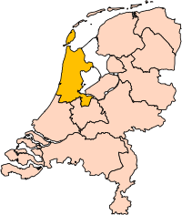
| Descriziun | Location of the province of Noord-Holland (North Holland) in the Netherlands. |
| Data | |
| Funtana | Own work, based on freely available GIS data |
| Autur | User:Mtcv |
| Lizënza (Tó ca danü chësc file) |
Data: attribution required; my work: PD |
| Altre versioni | I attempted to make an svg version of Image:Noord Holland-Position.png (with less simplified boundaries) |
Clickable version

Lizënza

|
Il detentore del copyright di questo file, Centraal Bureau voor de Statistiek, permette a chiunque di utilizzarlo per qualsiasi scopo, a condizione che il detentore del copyright venga riconosciuto come tale. Sono consentiti la redistribuzione, le opere derivate, la modifica, l'uso commerciale ed ogni altro uso. |
Atribuzion:
|
| Annotations | This image is annotated: View the annotations at Commons |


Storia dl documënt
Druca sun na data/ëura per udëi l documënt coche l fo te chël mumënt.
| Data/Ëura | Miniatura | Grandëza | utënt | Cumentar | |
|---|---|---|---|---|---|
| atuel | 19:20, 2 mer 2019 | | 200 × 236 (158 KB) | Thayts | update |
| 17:13, 2 uto 2006 |  | 200 × 236 (158 KB) | Mtcv | {{Information| |Description=Location of the province of Noord-Holland (North Holland) in the Netherlands. |Source=Own work, based on freely available GIS data |Date=2006-10-02 |Author=User:Mtcv |Permission=Data: attribution required; my work: PD |othe |
Coche l document ie stat adurvà
L ne da deguna plates che adroa chësc documënt.
Coche l documënt ie stat adurvà ntëur l mond
Ënghe chësta wikis adroa chësc documënt:
- Adurvà sun ar.wikipedia.org
- أمستردام
- شمال-هولندا
- هلفرسوم
- ألكمار
- هارلم (شمال-هولندا)
- زانستاد
- هارلمرمير
- قالب:بلديات شمال هولندا
- سخاخن
- دن هيلدر
- فيلسن
- زانتفورت
- بلوميندال
- ألسمير
- لاندسمير
- أوستزان
- تيسل
- أمستلفين
- إنكهاوزن
- هورن (هولندا)
- فاترلاند
- بيمستر
- بيفيرفايك
- بيرخن (شمال هولندا)
- بلاريكوم
- هيمستيده
- بوابة:أمستردام/قوالب
- بوابة:أمستردام
- حكومة أمستردام
- هارلمرليده آن سبارنفاودا
- آودر- أمستل
- ديمين
- فيسب (هولندا)
- كاستركوم
- دريخترلاند
- إدام- فولندام
- هيمسكيرك
- هيرهوخوفارد
- هيلو (هولندا)
- هولاندز كرون
- هاوزن
- كوخينلاند
- لانجادايك
- لارين (هولندا)
- ميديمبليك
- أوبمير
- بورميراند
- ستيده بروك
- آوتخيست
- آوتهورن
Mostra utilisaziun globala de chësc file.