
File:Pamir topographic map-fr.svg

Dimensioni di questa anteprima PNG per questo file SVG: 800 x 513 pixel. Autra resoluzions: 320 x 205 pixel | 640 x 410 pixel | 1 024 x 656 pixel | 1 280 x 820 pixel | 2 560 x 1 641 pixel | 3 543 x 2 271 pixel.
Documënt uriginel (file tl format SVG, dimenjiuns nominales 3 543 × 2 271 pixels, dimenjiun dl file: 4,41 MB)
Ressumé
| Luogo dello scatto | | Posizione di questa e altre immagini su: OpenStreetMap |
|---|
| Descriziun |
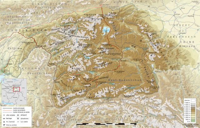
Deutsch: Topographische Karte zum Pamir, in Französische
English: Topographic map in French language of Pamir Mountains
Español: Mapa topográfico en francès de la Cordillera del Pamir
Italiano: Carta topografica del Pamir (en francese)
日本語: パミール高原の地図
Português: Carta topográfica e da administração do Pamir em francês
|
||
| Data | (UTC) | ||
| Funtana |
Création personnelle ;
|
||
| Autur | © Bourrichon (talk) - fr:Bourrichon | ||
| Lizënza (Tó ca danü chësc file) |
|
||
| Altre versioni |
Add-your-version : Template:Other versions/Pamir Template:Other versions/Pamir |
![[1]](http://www.pamirs.org/images/maps/pamir-gr.jpg)

|
This SVG file contains embedded text that can be translated into your language, using any capable SVG editor, text editor or the SVG Translate tool. For more information see: About translating SVG files. |
Questa grafica vettoriale non specificata secondo il W3C è stata creata con Inkscape .
Lizënza
Io, detentore del copyright su quest'opera, dichiaro di pubblicarla con le seguenti licenze:

|
AL é la lizënza da copié, da dé inant y/o müdé chësc documënt aladô dla lizënza GNU Free Documentation License, Verjiun 1.2 o vigni atra verjiun suandënta publicada dala Free Software Foundation; zënza seziuns che ara ne vá nia da mudé, zënza test söl cuertl ca dant y do ia. Na copia dla lizënza é tla seziun cun le titul Test dla GNU Free Documentation License. |
Questo file è disponibile in base alle licenze Creative Commons Attribuzione-Condividi allo stesso modo 3.0 Unported, 2.5 Generico, 2.0 Generico e 1.0 Generico
- Tu ies liede:
- da spartì – per cupié, spartësc y manda l lëur
- da mudé – da adaté al lëur
- A chësta condizions:
- atribuzion – Tu mues atribué l lëur te la maniera che à spiegà l autëur o chël che à la lizënza (ma nia te na maniera che l smea che ëi te paiessa).
- fá na condivijiun tla medema manira – Sce te mudes o svilupeies chësc test, pudres mé spartì ora l lëur sota la medema lizënza o una che ti smea a chësta same or compatible license
Pos chirí fora la lizënza che as plü ion
| Annotations | This image is annotated: View the annotations at Commons |
Storia dl documënt
Druca sun na data/ëura per udëi l documënt coche l fo te chël mumënt.
| Data/Ëura | Miniatura | Grandëza | utënt | Cumentar | |
|---|---|---|---|---|---|
| atuel | 18:39, 28 aur 2012 | | 3 543 × 2 271 (4,41 MB) | Bourrichon | Reverted to version as of 00:03, 23 April 2012 |
| 18:36, 28 aur 2012 |  | 3 543 × 2 271 (4,18 MB) | Bourrichon | allègement → simple svg | |
| 02:03, 23 aur 2012 |  | 3 543 × 2 271 (4,41 MB) | Bourrichon | mini bug | |
| 01:51, 23 aur 2012 |  | 3 543 × 2 271 (4,4 MB) | Bourrichon | ||
| 19:02, 21 aur 2012 |  | 3 543 × 2 271 (4,32 MB) | Bourrichon | Glacier Fedchenko | |
| 18:28, 21 aur 2012 |  | 3 543 × 2 271 (4,32 MB) | Bourrichon | ||
| 17:23, 20 aur 2012 |  | 3 543 × 2 271 (4,32 MB) | Bourrichon | +mines/querry ; + airport/aerodrome | |
| 16:39, 20 aur 2012 |  | 3 543 × 2 271 (4,28 MB) | Bourrichon | ||
| 16:34, 20 aur 2012 |  | 3 543 × 2 271 (4,12 MB) | Bourrichon | -bug typo | |
| 16:25, 20 aur 2012 |  | 3 543 × 2 271 (3,85 MB) | Bourrichon | == {{int:filedesc}} == {{coord|38.5|N|72.5|E|region:TJ_type:mountain_dim:500000|format=dms|display=title}} {{Information |Description= {{fr|Carte topographique en français du massif du fr:Pamir, au fr:Tadjikistan.}} {{de|Topographische Ka... |
Coche l document ie stat adurvà
Chësta 2 plates adroa chësc documënt:
Coche l documënt ie stat adurvà ntëur l mond
Ënghe chësta wikis adroa chësc documënt:
- Adurvà sun arz.wikipedia.org
- Adurvà sun ba.wikipedia.org
- Adurvà sun be.wikipedia.org
- Adurvà sun bg.wikipedia.org
- Adurvà sun ceb.wikipedia.org
- Adurvà sun de.wikipedia.org
- Adurvà sun es.wikipedia.org
- Adurvà sun et.wikipedia.org
- Adurvà sun fr.wikipedia.org
- Pamir
- Utilisateur:Gemini1980
- Portail:Afghanistan
- Wikipédia:Sélection/Afghanistan
- Wikipédia:Sélection/Kirghizistan
- Wikipédia:Sélection/Tadjikistan
- Wikipédia:Sélection/Montagne
- Discussion Wikipédia:Wikiconcours/mars 2012/Équipes/Équipe 5
- Chaînon Kashgar
- Chaînon de l'Académie des Sciences
- Chaînon Trans-Alaï
- Chaînon Yazgoulem
- Chaînon Pierre Ier
- Chaînon Shakhdara
- Chaînon Sarikol
- Chaînon Muskol
- Chaînon Rushan
- Chaînon Darvaz
- Chaînon Shugnan
- Chaînon Alitshur méridional
- Wikipédia:Lumière sur/Septembre 2012
- Wikipédia:Lumière sur/Pamir
Mostra utilisaziun globala de chësc file.