
File:Penang south Kedah heightmap ASTGTM2 N05E100 dem.png

Dimenjiuns de chësta odüda danfora:600 x 600 pixel. Autra resoluzions: 240 x 240 pixel | 480 x 480 pixel | 768 x 768 pixel | 1 024 x 1 024 pixel | 2 048 x 2 048 pixel | 3 601 x 3 601 pixel.
Documënt uriginel (3 601 × 3 601 pixels, dimenjiun dl file: 8,41 MB, MIME type: image/png)
Ressumé
| Descriziun |
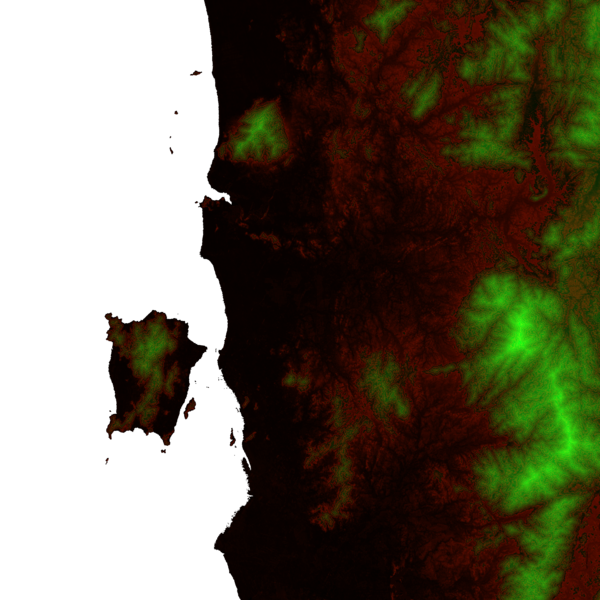
English: A heightmap of Penang state and the southern part of Kedah with contour discontinuities every 100 m, plotted from ASTER Global Digital Elevation Model data at http://step.esa.int/auxdata/dem/SRTMGL1 and coloured as follows:
|
| Funtana | Opera personala |
| Autur | Cmglee |
| Altre versioni |
 |
Lizënza
Io, detentore del copyright su quest'opera, dichiaro di pubblicarla con le seguenti licenze:
Chësc file á la lizënza de destribuziun aladô dla lizënza Creative Commons Attribution-Share Alike 3.0 Unported.
- Tu ies liede:
- da spartì – per cupié, spartësc y manda l lëur
- da mudé – da adaté al lëur
- A chësta condizions:
- atribuzion – Tu mues atribué l lëur te la maniera che à spiegà l autëur o chël che à la lizënza (ma nia te na maniera che l smea che ëi te paiessa).
- fá na condivijiun tla medema manira – Sce te mudes o svilupeies chësc test, pudres mé spartì ora l lëur sota la medema lizënza o una che ti smea a chësta same or compatible license

|
AL é la lizënza da copié, da dé inant y/o müdé chësc documënt aladô dla lizënza GNU Free Documentation License, Verjiun 1.2 o vigni atra verjiun suandënta publicada dala Free Software Foundation; zënza seziuns che ara ne vá nia da mudé, zënza test söl cuertl ca dant y do ia. Na copia dla lizënza é tla seziun cun le titul Test dla GNU Free Documentation License. |
Pos chirí fora la lizënza che as plü ion
Storia dl documënt
Druca sun na data/ëura per udëi l documënt coche l fo te chël mumënt.
| Data/Ëura | Miniatura | Grandëza | utënt | Cumentar | |
|---|---|---|---|---|---|
| atuel | 20:59, 29 uto 2013 | | 3 601 × 3 601 (8,41 MB) | Cmglee | {{Information |Description ={{en|1=A heightmap of Penang state and the southern part of Kedah with contour discontinuities every 100 m, plotted from ASTER Global Digital Elevation Model data at http://gdem.ersdac.jspacesystems.or.jp/download.jsp and... |
Coche l document ie stat adurvà
Chësta plata adroa chësc documënt:
Coche l documënt ie stat adurvà ntëur l mond
Ënghe chësta wikis adroa chësc documënt:
- Adurvà sun ceb.wikipedia.org
- Adurvà sun en.wikipedia.org
- Adurvà sun fa.wikipedia.org
- Adurvà sun it.wikivoyage.org
- Adurvà sun ta.wikipedia.org
- Adurvà sun www.wikidata.org