
File:River Sheppey in Croscombe.jpg
Degöna resoluziun plü alta desponibla.
River_Sheppey_in_Croscombe.jpg (640 × 480 pixels, dimenjiun dl file: 140 KB, MIME type: image/jpeg)
Ressumé
| Descriziun |
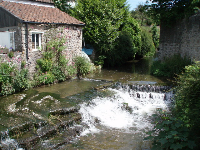
English: River Sheppey in Croscombe. The course of the river Sheppey has been substantially 'managed' on its way through Croscombe, as this small weir area demonstrates. The Sheppey was the main power source for many of the mills (now gone) which functioned in Croscombe in the 18th and 19th centuries. |
| Data | |
| Funtana | From geograph.org.uk |
| Autur | Sharon Loxton |
| Luogo dello scatto | | Posizione di questa e altre immagini su: OpenStreetMap |
|---|
Lizënza

|
Questa immagine proviene dalla collezione del progetto Geograph. Vedi questa fotografia sul sito web di Geograph per visualizzare i dettagli relativi al fotografo. Il copyright di questa immagine appartiene a Sharon Loxton ed è pubblicata secondo i termini della licenza Creative Commons Attribuzione-Condividi allo stesso modo 2.0.
|
Questo file è disponibile in base alla licenza Creative Commons Attribuzione-Condividi allo stesso modo 2.0 Generico
Atribuzion: Sharon Loxton
- Tu ies liede:
- da spartì – per cupié, spartësc y manda l lëur
- da mudé – da adaté al lëur
- A chësta condizions:
- atribuzion – Tu mues atribué l lëur te la maniera che à spiegà l autëur o chël che à la lizënza (ma nia te na maniera che l smea che ëi te paiessa).
- fá na condivijiun tla medema manira – Sce te mudes o svilupeies chësc test, pudres mé spartì ora l lëur sota la medema lizënza o una che ti smea a chësta same or compatible license
Storia dl documënt
Druca sun na data/ëura per udëi l documënt coche l fo te chël mumënt.
| Data/Ëura | Miniatura | Grandëza | utënt | Cumentar | |
|---|---|---|---|---|---|
| atuel | 02:11, 21 sët 2007 | | 640 × 480 (140 KB) | Derek Andrews | {{Information |Description=The course of the river Sheppey has been substantially 'managed' on its way through Croscombe, as this small weir area demonstrates. The Sheppey was the main power source for many of the mills which operated in Croscombe in the |
Coche l document ie stat adurvà
Chësta plata adroa chësc documënt:
Coche l documënt ie stat adurvà ntëur l mond
Ënghe chësta wikis adroa chësc documënt:
- Adurvà sun ceb.wikipedia.org
- Adurvà sun en.wikipedia.org
- Adurvà sun es.wikipedia.org
- Adurvà sun fr.wikipedia.org
- Adurvà sun mt.wikipedia.org
- Adurvà sun nl.wikipedia.org
- Adurvà sun pl.wikipedia.org
- Adurvà sun www.wikidata.org
- Adurvà sun zh-min-nan.wikipedia.org