
File:Skagit River 8810s.JPG

Dimenjiuns de chësta odüda danfora:800 x 533 pixel. Autra resoluzions: 320 x 213 pixel | 640 x 427 pixel | 1 024 x 683 pixel | 1 280 x 853 pixel | 2 560 x 1 707 pixel | 5 124 x 3 416 pixel.
Documënt uriginel (5 124 × 3 416 pixels, dimenjiun dl file: 8,17 MB, MIME type: image/jpeg)
Ressumé
| Descriziun |
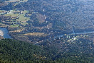
English: Skagit River Washington State Route 530 (center); Rockport, Washington (lower right); Martin Road (left); Rockport Cascade Road (upper left)
|
| Data | 28 utober 2013, 22:30:49 +00:00 |
| Funtana | Opera personala |
| Autur | Walter Siegmund (talk) |
| Altre versioni |
|


| Luogo dello scatto | | Posizione di questa e altre immagini su: OpenStreetMap |
|---|
| Modello fotocamera | Canon EOS DIGITAL REBEL XSi |
|---|---|
| Tempo esposizione | 1/200 |
| Diaframma | f/8.0 |
| Velocità pellicola (ISO/ASA) | 400 |
| Filtro/i | Hoya Circular Polarizer, HOCPMC67 |

|
This image is the work of Walter Siegmund
|
Lizënza
Io, detentore del copyright su quest'opera, dichiaro di pubblicarla con la seguente licenza:
Chësc file á la lizënza de destribuziun aladô dla lizënza Creative Commons Attribution-Share Alike 3.0 Unported.
- Tu ies liede:
- da spartì – per cupié, spartësc y manda l lëur
- da mudé – da adaté al lëur
- A chësta condizions:
- atribuzion – Tu mues atribué l lëur te la maniera che à spiegà l autëur o chël che à la lizënza (ma nia te na maniera che l smea che ëi te paiessa).
- fá na condivijiun tla medema manira – Sce te mudes o svilupeies chësc test, pudres mé spartì ora l lëur sota la medema lizënza o una che ti smea a chësta same or compatible license
Storia dl documënt
Druca sun na data/ëura per udëi l documënt coche l fo te chël mumënt.
| Data/Ëura | Miniatura | Grandëza | utënt | Cumentar | |
|---|---|---|---|---|---|
| atuel | 00:01, 15 jen 2015 | | 5 124 × 3 416 (8,17 MB) | Wsiegmund |
Coche l document ie stat adurvà
Chësta plata adroa chësc documënt:
Coche l documënt ie stat adurvà ntëur l mond
Ënghe chësta wikis adroa chësc documënt:
- Adurvà sun ar.wikipedia.org
- Adurvà sun azb.wikipedia.org
- Adurvà sun ca.wikipedia.org
- Adurvà sun ceb.wikipedia.org
- Adurvà sun ce.wikipedia.org
- Adurvà sun de.wikipedia.org
- Adurvà sun en.wikipedia.org
- Adurvà sun es.wikipedia.org
- Adurvà sun eu.wikipedia.org
- Adurvà sun fa.wikipedia.org
- Adurvà sun fr.wikipedia.org
- Adurvà sun hu.wikipedia.org
- Adurvà sun it.wikipedia.org
- Adurvà sun pl.wikipedia.org
- Adurvà sun pt.wikipedia.org
- Adurvà sun sr.wikipedia.org
- Adurvà sun tt.wikipedia.org
- Adurvà sun uk.wikipedia.org
- Adurvà sun ur.wikipedia.org
- Adurvà sun uz.wikipedia.org
- Adurvà sun www.wikidata.org
- Adurvà sun zh-min-nan.wikipedia.org