
File:St Blaise, Haccombe - geograph.org.uk - 825022.jpg

Documënt uriginel (480 × 640 pixels, dimenjiun dl file: 103 KB, MIME type: image/jpeg)
Ressumé
| Descriziun |
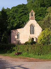
English: St Blaise, Haccombe A singular church, perhaps of as much interest as any other of its size, and possibly dating from 1233, certainly the C13. "The Rector of the church holds the rare title of Archpriest a privilege founded in medieval times and ratified in 1913 by King George V. This entitles him to wear lawn sleeves, like a bishop, and a fur stole, or amyss." (http://www.pbs.org.uk/news/index.asp ) (The more usual spelling would be "amice"). This title reflects the fact that the Archpriest has the right to sit beside the Bishop at ceremonies, and recognises no authority lower than the Archbishop of Canterbury.
The Amice is a rectangle of white linen worn as a neck-cloth or hood with the alb and other vestments at the Eucharist. Not to be confused with the Amyss or Almuce, which is as stated in the preceding paragraph a stole-like garment of animal fur, worn over the surplice by canons, archpriests and other dignitaries in lieu of the Tippet or Black Scarf at Mattins and Evensong. (Note by Hugh Allen, 30 April 2021) Reverend William Keble Martin, the artist of Concise British Flora fame, held the position of Archpriest here from 1921 to 1934. The church was praised by the Prayer Book Society in March 2008 for using only the 1662 Book of Common Prayer. The bell, dating from 1290, may be the oldest in Devon, and there are several remarkable monuments. |
| Data | |
| Funtana | From geograph.org.uk |
| Autur | Derek Harper |
| Atribuzion (richiesto dalla licenza) | Derek Harper / St Blaise, Haccombe / |
| Luogo dello scatto | | Posizione di questa e altre immagini su: OpenStreetMap |
|---|
_heading:67.00&language=lld)
| Posizione del soggetto | | Posizione di questa e altre immagini su: OpenStreetMap |
|---|
_heading:67.00&language=lld)
Lizënza

|
Questa immagine proviene dalla collezione del progetto Geograph. Vedi questa fotografia sul sito web di Geograph per visualizzare i dettagli relativi al fotografo. Il copyright di questa immagine appartiene a Derek Harper ed è pubblicata secondo i termini della licenza Creative Commons Attribuzione-Condividi allo stesso modo 2.0.
|
- Tu ies liede:
- da spartì – per cupié, spartësc y manda l lëur
- da mudé – da adaté al lëur
- A chësta condizions:
- atribuzion – Tu mues atribué l lëur te la maniera che à spiegà l autëur o chël che à la lizënza (ma nia te na maniera che l smea che ëi te paiessa).
- fá na condivijiun tla medema manira – Sce te mudes o svilupeies chësc test, pudres mé spartì ora l lëur sota la medema lizënza o una che ti smea a chësta same or compatible license
Storia dl documënt
Druca sun na data/ëura per udëi l documënt coche l fo te chël mumënt.
| Data/Ëura | Miniatura | Grandëza | utënt | Cumentar | |
|---|---|---|---|---|---|
| atuel | 18:57, 20 fau 2011 | | 480 × 640 (103 KB) | GeographBot | == {{int:filedesc}} == {{Information |description={{en|1=St Blaise, Haccombe A singular church, perhaps of as much interest as any other of its size, and possibly dating from 1233, certainly the C13. "The Rector of the church holds the rare title of Archp |
Coche l document ie stat adurvà
Chësta plata adroa chësc documënt:
Coche l documënt ie stat adurvà ntëur l mond
Ënghe chësta wikis adroa chësc documënt:
- Adurvà sun en.wikipedia.org
- Adurvà sun it.wikipedia.org
- Adurvà sun pl.wikipedia.org
- Adurvà sun sv.wikipedia.org
- Adurvà sun www.wikidata.org