
File:St Helen, East Keal - geograph.org.uk - 430623.jpg
Degöna resoluziun plü alta desponibla.
St_Helen,_East_Keal_-_geograph.org.uk_-_430623.jpg (640 × 480 pixels, dimenjiun dl file: 138 KB, MIME type: image/jpeg)
Ressumé
| Descriziun |
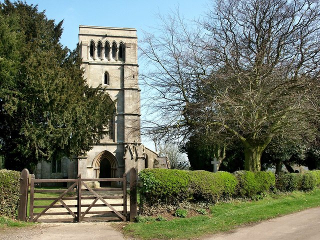
English: St Helen, East Keal The church of St Helen at East Keal, like that of St Helen at West Keal, stands on the very southern edge of the Wolds. It was almost entirely rebuilt in 1854 leaving just the south arcade, 13th-century and the north arcade, 14th-century. The octagonal 14th-century font has carvings flowers, leaves, grotesque heads and a bare backside!
In the south aisle, there is a small Elizabethan tablet inscribed Susanna Kirkman, which shows a seated figure, elbow resting on a skull with an extinguished torch in her other hand. There is also a bust of Peter Short who died in 1681. |
| Data | |
| Funtana | From geograph.org.uk |
| Autur | Dave Hitchborne |
| Atribuzion (richiesto dalla licenza) | Dave Hitchborne / St Helen, East Keal / |
| Luogo dello scatto | | Posizione di questa e altre immagini su: OpenStreetMap |
|---|
_heading:90.00&language=lld)
| Posizione del soggetto | | Posizione di questa e altre immagini su: OpenStreetMap |
|---|
_heading:90.00&language=lld)
Lizënza

|
Questa immagine proviene dalla collezione del progetto Geograph. Vedi questa fotografia sul sito web di Geograph per visualizzare i dettagli relativi al fotografo. Il copyright di questa immagine appartiene a Dave Hitchborne ed è pubblicata secondo i termini della licenza Creative Commons Attribuzione-Condividi allo stesso modo 2.0.
|
Questo file è disponibile in base alla licenza Creative Commons Attribuzione-Condividi allo stesso modo 2.0 Generico
Atribuzion: Dave Hitchborne
- Tu ies liede:
- da spartì – per cupié, spartësc y manda l lëur
- da mudé – da adaté al lëur
- A chësta condizions:
- atribuzion – Tu mues atribué l lëur te la maniera che à spiegà l autëur o chël che à la lizënza (ma nia te na maniera che l smea che ëi te paiessa).
- fá na condivijiun tla medema manira – Sce te mudes o svilupeies chësc test, pudres mé spartì ora l lëur sota la medema lizënza o una che ti smea a chësta same or compatible license
Storia dl documënt
Druca sun na data/ëura per udëi l documënt coche l fo te chël mumënt.
| Data/Ëura | Miniatura | Grandëza | utënt | Cumentar | |
|---|---|---|---|---|---|
| atuel | 11:02, 4 fau 2011 | | 640 × 480 (138 KB) | GeographBot | == {{int:filedesc}} == {{Information |description={{en|1=St Helen, East Keal The church of St Helen at East Keal, like that of St Helen at West Keal, stands on the very southern edge of the Wolds. It was almost entirely rebuilt in 1854 leaving just the so |
Coche l document ie stat adurvà
Chësta plata adroa chësc documënt:
Coche l documënt ie stat adurvà ntëur l mond
Ënghe chësta wikis adroa chësc documënt:
- Adurvà sun ceb.wikipedia.org
- Adurvà sun cy.wikipedia.org
- Adurvà sun en.wikipedia.org
- Adurvà sun fa.wikipedia.org
- Adurvà sun fr.wikipedia.org
- Adurvà sun it.wikipedia.org
- Adurvà sun nl.wikipedia.org
- Adurvà sun sv.wikipedia.org
- Adurvà sun www.wikidata.org