
File:St Helen, Mareham-le-Fen - geograph.org.uk - 105510.jpg
Degöna resoluziun plü alta desponibla.
St_Helen,_Mareham-le-Fen_-_geograph.org.uk_-_105510.jpg (640 × 480 pixels, dimenjiun dl file: 99 KB, MIME type: image/jpeg)
Ressumé
| Descriziun |
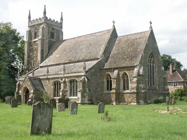
English: St Helen, Mareham-le-Fen. The earliest parts of the church date from about 1270 and they are the lower part of the tower and the tower arch. The church was largely restored in the 1870s, when the 14th-century chancel was almost entirely rebuilt. Further restoration work was done in the late 1960s and early 1970s. When the Mediaeval church of St Margaret, Old Woodhall was demolished, much of the material was brought over to build the new north vestry, kitchenette and vestibule. The font dates from the 14th-century, but the cover is modern. The registers were begun in 1558. The James Roberts gravestone, near the north door, was brought into the church to avoid further erosion. It commemorates the first voyage around the world under Captain James Cook. The famous botanist Joseph Banks from nearby Revesby was also aboard. |
| Data | |
| Funtana | From geograph.org.uk |
| Autur | Dave Hitchborne |
| Atribuzion (richiesto dalla licenza) | Dave Hitchborne / St Helen, Mareham-le-Fen / |
| Luogo dello scatto | | Posizione di questa e altre immagini su: OpenStreetMap |
|---|
_&language=lld)
| Posizione del soggetto | | Posizione di questa e altre immagini su: OpenStreetMap |
|---|
_&language=lld)
Lizënza

|
Questa immagine proviene dalla collezione del progetto Geograph. Vedi questa fotografia sul sito web di Geograph per visualizzare i dettagli relativi al fotografo. Il copyright di questa immagine appartiene a Dave Hitchborne ed è pubblicata secondo i termini della licenza Creative Commons Attribuzione-Condividi allo stesso modo 2.0.
|
Questo file è disponibile in base alla licenza Creative Commons Attribuzione-Condividi allo stesso modo 2.0 Generico
Atribuzion: Dave Hitchborne
- Tu ies liede:
- da spartì – per cupié, spartësc y manda l lëur
- da mudé – da adaté al lëur
- A chësta condizions:
- atribuzion – Tu mues atribué l lëur te la maniera che à spiegà l autëur o chël che à la lizënza (ma nia te na maniera che l smea che ëi te paiessa).
- fá na condivijiun tla medema manira – Sce te mudes o svilupeies chësc test, pudres mé spartì ora l lëur sota la medema lizënza o una che ti smea a chësta same or compatible license
Storia dl documënt
Druca sun na data/ëura per udëi l documënt coche l fo te chël mumënt.
| Data/Ëura | Miniatura | Grandëza | utënt | Cumentar | |
|---|---|---|---|---|---|
| atuel | 03:52, 31 jen 2010 | | 640 × 480 (99 KB) | GeographBot | == {{int:filedesc}} == {{Information |description={{en|1=St Helen, Mareham-le-Fen. The earliest parts of the church date from about 1270 and they are the lower part of the tower and the tower arch. The church was largely restored in the 1870s, when the 14 |
Coche l document ie stat adurvà
Chësta plata adroa chësc documënt:
Coche l documënt ie stat adurvà ntëur l mond
Ënghe chësta wikis adroa chësc documënt:
- Adurvà sun ceb.wikipedia.org
- Adurvà sun cy.wikipedia.org
- Adurvà sun de.wikipedia.org
- Adurvà sun en.wikipedia.org
- Adurvà sun es.wikipedia.org
- Adurvà sun fa.wikipedia.org
- Adurvà sun fr.wikipedia.org
- Adurvà sun it.wikipedia.org
- Adurvà sun pl.wikipedia.org
- Adurvà sun www.wikidata.org