
File:St Lawrence, Fulstow - geograph.org.uk - 433108.jpg
Degöna resoluziun plü alta desponibla.
St_Lawrence,_Fulstow_-_geograph.org.uk_-_433108.jpg (640 × 480 pixels, dimenjiun dl file: 81 KB, MIME type: image/jpeg)
Ressumé
| Descriziun |
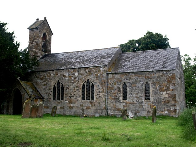
English: St Lawrence, Fulstow The walls of the church of St Lawrence have the remains of arcades, which point to the fact that there were north and south aisles and that this building comes from the Early English period - about 1160 to 1180. There are the remains of three bays on the outer wall of the south side and two on the north. The font is also Early English. Inside the porch entrance are two 14th century effigies of a cross-legged knight, Sir Robert de Hilton, and his lady.
On this day, a note in the porch read, "St Lawrence and Flower Cleaning Roaster." I guess it should have said, "Flower Arranging and Cleaning Roster". |
| Data | |
| Funtana | From geograph.org.uk |
| Autur | Dave Hitchborne |
| Atribuzion (richiesto dalla licenza) | Dave Hitchborne / St Lawrence, Fulstow / |
| Luogo dello scatto | | Posizione di questa e altre immagini su: OpenStreetMap |
|---|
_heading:337.00&language=lld)
| Posizione del soggetto | | Posizione di questa e altre immagini su: OpenStreetMap |
|---|
_heading:337.00&language=lld)
Lizënza

|
Questa immagine proviene dalla collezione del progetto Geograph. Vedi questa fotografia sul sito web di Geograph per visualizzare i dettagli relativi al fotografo. Il copyright di questa immagine appartiene a Dave Hitchborne ed è pubblicata secondo i termini della licenza Creative Commons Attribuzione-Condividi allo stesso modo 2.0.
|
Questo file è disponibile in base alla licenza Creative Commons Attribuzione-Condividi allo stesso modo 2.0 Generico
Atribuzion: Dave Hitchborne
- Tu ies liede:
- da spartì – per cupié, spartësc y manda l lëur
- da mudé – da adaté al lëur
- A chësta condizions:
- atribuzion – Tu mues atribué l lëur te la maniera che à spiegà l autëur o chël che à la lizënza (ma nia te na maniera che l smea che ëi te paiessa).
- fá na condivijiun tla medema manira – Sce te mudes o svilupeies chësc test, pudres mé spartì ora l lëur sota la medema lizënza o una che ti smea a chësta same or compatible license
Storia dl documënt
Druca sun na data/ëura per udëi l documënt coche l fo te chël mumënt.
| Data/Ëura | Miniatura | Grandëza | utënt | Cumentar | |
|---|---|---|---|---|---|
| atuel | 11:03, 4 fau 2011 | | 640 × 480 (81 KB) | GeographBot | == {{int:filedesc}} == {{Information |description={{en|1=St Lawrence, Fulstow The walls of the church of St Lawrence have the remains of arcades, which point to the fact that there were north and south aisles and that this building comes from the Early En |
Coche l document ie stat adurvà
Chësta plata adroa chësc documënt:
Coche l documënt ie stat adurvà ntëur l mond
Ënghe chësta wikis adroa chësc documënt:
- Adurvà sun ceb.wikipedia.org
- Adurvà sun cy.wikipedia.org
- Adurvà sun en.wikipedia.org
- Adurvà sun es.wikipedia.org
- Adurvà sun fa.wikipedia.org
- Adurvà sun fr.wikipedia.org
- Adurvà sun it.wikipedia.org
- Adurvà sun nl.wikipedia.org
- Adurvà sun www.wikidata.org