
File:The Battery, north of Caermote, near Bothel - geograph.org.uk - 75018.jpg
Degöna resoluziun plü alta desponibla.
The_Battery,_north_of_Caermote,_near_Bothel_-_geograph.org.uk_-_75018.jpg (640 × 458 pixels, dimenjiun dl file: 172 KB, MIME type: image/jpeg)
Ressumé
| Descriziun |
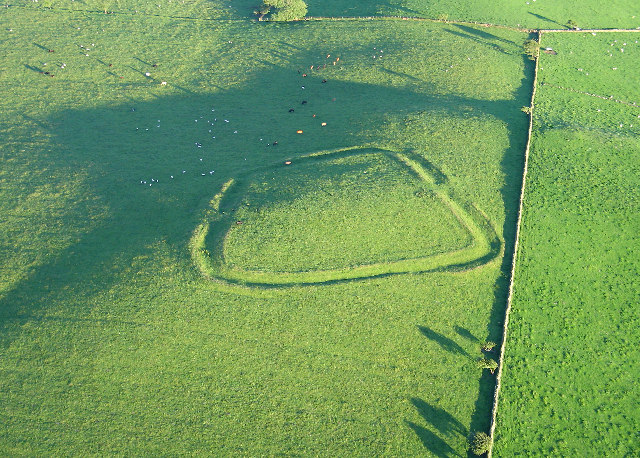
English: The Battery, north of Caermote, near Bothel. The only feature of interest in this grid square is seen best from this vantage point when the sun is low. Clearly it was an enclosure, but there is no record it was a battery and it has not been excavated. |
| Data | |
| Funtana | From geograph.org.uk |
| Autur | Simon Ledingham |
| Atribuzion (richiesto dalla licenza) | Simon Ledingham / The Battery, north of Caermote, near Bothel / |
| Luogo dello scatto | | Posizione di questa e altre immagini su: OpenStreetMap |
|---|
_&language=lld)
| Posizione del soggetto | | Posizione di questa e altre immagini su: OpenStreetMap |
|---|
_&language=lld)
Lizënza

|
Questa immagine proviene dalla collezione del progetto Geograph. Vedi questa fotografia sul sito web di Geograph per visualizzare i dettagli relativi al fotografo. Il copyright di questa immagine appartiene a Simon Ledingham ed è pubblicata secondo i termini della licenza Creative Commons Attribuzione-Condividi allo stesso modo 2.0.
|
Questo file è disponibile in base alla licenza Creative Commons Attribuzione-Condividi allo stesso modo 2.0 Generico
Atribuzion: Simon Ledingham
- Tu ies liede:
- da spartì – per cupié, spartësc y manda l lëur
- da mudé – da adaté al lëur
- A chësta condizions:
- atribuzion – Tu mues atribué l lëur te la maniera che à spiegà l autëur o chël che à la lizënza (ma nia te na maniera che l smea che ëi te paiessa).
- fá na condivijiun tla medema manira – Sce te mudes o svilupeies chësc test, pudres mé spartì ora l lëur sota la medema lizënza o una che ti smea a chësta same or compatible license
- Remove redundant categories and try to put this image in the most specific category/categories
- Remove this template
- The location categories are based on information from this geonames tool and this OpenStreetMap tool combined with a database. You can also have a look at this tool from mysociety.
- The topic category from Geograph was Historic site (find similar images site at Geograph)
Storia dl documënt
Druca sun na data/ëura per udëi l documënt coche l fo te chël mumënt.
| Data/Ëura | Miniatura | Grandëza | utënt | Cumentar | |
|---|---|---|---|---|---|
| atuel | 21:47, 30 jen 2010 | | 640 × 458 (172 KB) | GeographBot | == {{int:filedesc}} == {{Information |description={{en|1=The Battery, north of Caermote, near Bothel. The only feature of interest in this grid square is seen best from this vantage point when the sun is low. Clearly it was an enclosure, but there is no |
Coche l document ie stat adurvà
Chësta plata adroa chësc documënt:
Coche l documënt ie stat adurvà ntëur l mond
Ënghe chësta wikis adroa chësc documënt:
- Adurvà sun arz.wikipedia.org
- Adurvà sun en.wikipedia.org
- Adurvà sun nn.wikipedia.org
- Adurvà sun www.wikidata.org