
File:Trig. point at Ridley - geograph.org.uk - 151530.jpg
Degöna resoluziun plü alta desponibla.
Trig._point_at_Ridley_-_geograph.org.uk_-_151530.jpg (640 × 485 pixels, dimenjiun dl file: 79 KB, MIME type: image/jpeg)
Ressumé
| Descriziun |
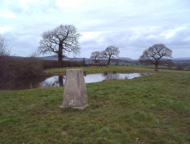
English: Trig. point at Ridley The view is to the NW. The trig. point (alt. 125m) lies just E of the A49 and just N of the A534 in the parish of Ridley. A telephone mast and covered reservoir lie just behind the photographer. This is the high point of the undulating land east of the Peckforton Hills and south of the Beeston Gap. The Peckforton Hills are seen in the distance, with Peckforton Castle on the central skyline 5 km away and Beeston Castle just visible on the skyline a little further to the right on its isolated hill nearly 6 km away. This part of Cheshire seems not to know whether it is supposed to be the Cheshire Plain or the sandstone hills and has a character of its own. |
| Data | |
| Funtana | From geograph.org.uk |
| Autur | Mike Harris |
| Atribuzion (richiesto dalla licenza) | Mike Harris / Trig. point at Ridley / |
| Posizione del soggetto | | Posizione di questa e altre immagini su: OpenStreetMap |
|---|
_heading:315.00&language=lld)
Lizënza

|
Questa immagine proviene dalla collezione del progetto Geograph. Vedi questa fotografia sul sito web di Geograph per visualizzare i dettagli relativi al fotografo. Il copyright di questa immagine appartiene a Mike Harris ed è pubblicata secondo i termini della licenza Creative Commons Attribuzione-Condividi allo stesso modo 2.0.
|
Questo file è disponibile in base alla licenza Creative Commons Attribuzione-Condividi allo stesso modo 2.0 Generico
Atribuzion: Mike Harris
- Tu ies liede:
- da spartì – per cupié, spartësc y manda l lëur
- da mudé – da adaté al lëur
- A chësta condizions:
- atribuzion – Tu mues atribué l lëur te la maniera che à spiegà l autëur o chël che à la lizënza (ma nia te na maniera che l smea che ëi te paiessa).
- fá na condivijiun tla medema manira – Sce te mudes o svilupeies chësc test, pudres mé spartì ora l lëur sota la medema lizënza o una che ti smea a chësta same or compatible license
- Remove redundant categories and try to put this image in the most specific category/categories
- Remove this template
- The location categories are based on information from this geonames tool and this OpenStreetMap tool combined with a database. You can also have a look at this tool from mysociety.
- The topic category from Geograph was Triangulation Pillar (find similar images Pillar at Geograph)
Storia dl documënt
Druca sun na data/ëura per udëi l documënt coche l fo te chël mumënt.
| Data/Ëura | Miniatura | Grandëza | utënt | Cumentar | |
|---|---|---|---|---|---|
| atuel | 13:53, 31 jen 2010 | | 640 × 485 (79 KB) | GeographBot | == {{int:filedesc}} == {{Information |description={{en|1=Trig. point at Ridley The view is to the NW. The trig. point (alt. 125m) lies just E of the A49 and just N of the A534 in the parish of Ridley. A telephone mast and covered reservoir lie just behind |
Coche l document ie stat adurvà
Chësta plata adroa chësc documënt:
Coche l documënt ie stat adurvà ntëur l mond
Ënghe chësta wikis adroa chësc documënt:
- Adurvà sun ceb.wikipedia.org
- Adurvà sun en.wikipedia.org
- Adurvà sun fr.wikipedia.org
- Adurvà sun it.wikipedia.org
- Adurvà sun sv.wikipedia.org
- Adurvà sun www.wikidata.org