
File:WILSON'S MILL, FORMERLY KNOWN AS ALEXANDER'S MILL, ON THE OHIO-ERIE CANAL SOUTH OF ALEXANDER ROAD NEAR VALLEY VIEW... - NARA - 558001.jpg

Documënt uriginel (3 000 × 2 034 pixels, dimenjiun dl file: 1 001 KB, MIME type: image/jpeg)
|
Questa è un'immagine di un luogo o edificio che è elencato nel National Register of Historic Places negli Stati Uniti. Il suo numero di riferimento è [https://npgallery.nps.gov/AssetDetail/NRIS/79000298
. 79000298
.]. |
Ressumé
| Autur |
Frank J. (Frank John) Aleksandrowicz, 1921-, Photographer (NARA record: 8452210) |
||||||||||||||||||||||||||
| Record creator | Environmental Protection Agency. (12/02/1970 - ) | ||||||||||||||||||||||||||
| Titolo |
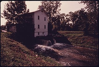
WILSON'S MILL, FORMERLY KNOWN AS ALEXANDER'S MILL, ON THE OHIO-ERIE CANAL SOUTH OF ALEXANDER ROAD NEAR VALLEY VIEW AND CLEVELAND, OHIO. WHEN IT OPERATED, CANAL WATER DROPPED THROUGH A SLUICE WHICH PROVIDED POWER TO GRIND GRAIN. THE CANAL CONNECTED THE GREAT LAKES WITH THE OHIO AND MISSISSIPPI RIVER SYSTEMS BETWEEN 1833 AND 1913 WHEN A FLOOD AND THE RAILROADS PUT THE WATERWAY OUT OF BUSINESS. THE SITE IS NOW PART OF THE CUYAHOGA VALLEY NATIONAL RECREATION AREA |
||||||||||||||||||||||||||
| Luogo rappresentato |
Cleveland (Cuyahoga county, Ohio, United States, North and Central America) inhabited place (41°28′59″N 81°40′59″W / 41.483°N 81.683°W; NARA geographical record) |
||||||||||||||||||||||||||
| Data | setëmber 1975 | ||||||||||||||||||||||||||
| Collezione |
|
||||||||||||||||||||||||||
| Record ID |
NAIL Control Number: NWDNS-412-DA-15551
|
||||||||||||||||||||||||||
| Funtana | U.S. National Archives and Records Administration | ||||||||||||||||||||||||||
| Altre versioni |
Please do not overwrite this file: any cropping or other restoration work should be uploaded with a new name and linked in this page's "other versions=" parameter, so that this file represents the exact file found in the NARA catalog record to which it links. The metadata on this page was imported directly from NARA's catalog record; additional descriptive text may be added by Wikimedians to the template below with the "description=" parameter, but please do not modify the other fields. tradurre
|
||||||||||||||||||||||||||


Lizënza
This file was provided to Wikimedia Commons by the National Archives and Records Administration as part of a cooperation project. The National Archives and Records Administration provides images depicting American and global history which are public domain or licensed under a free license.
|
Quest'immagine (o altro file multimediale) è un lavoro di un dipendente dell'Agenzia Statunitense per la Protezione dell'Ambiente, creato durante il suo servizio. Come lavoro del Governo federale degli Stati Uniti, tutte le immagini prodotte dall'EPA sono in pubblico dominio.
|
||
| Posizione del soggetto | | Posizione di questa e altre immagini su: OpenStreetMap |
|---|
Storia dl documënt
Druca sun na data/ëura per udëi l documënt coche l fo te chël mumënt.
| Data/Ëura | Miniatura | Grandëza | utënt | Cumentar | |
|---|---|---|---|---|---|
| atuel | 06:19, 20 uto 2011 | | 3 000 × 2 034 (1 001 KB) | US National Archives bot | == {{int:filedesc}} == {{NARA-image-full | Title = WILSON'S MILL, FORMERLY KNOWN AS ALEXANDER'S MILL, ON THE OHIO-ERIE CANAL SOUTH OF ALEXANDER ROAD NEAR VALLEY VIEW AND CLEVELAND, OHIO. WHEN IT OPERATED, CANAL WATER DROPPED THROUGH A |
Coche l document ie stat adurvà
Chësta plata adroa chësc documënt:
Coche l documënt ie stat adurvà ntëur l mond
Ënghe chësta wikis adroa chësc documënt:
- Adurvà sun ar.wikipedia.org
- Adurvà sun azb.wikipedia.org
- Adurvà sun ca.wikipedia.org
- Adurvà sun ceb.wikipedia.org
- Adurvà sun cy.wikipedia.org
- Adurvà sun en.wikipedia.org
- Adurvà sun en.wikivoyage.org
- Adurvà sun eu.wikipedia.org
- Adurvà sun fa.wikipedia.org
- Adurvà sun fr.wikipedia.org
- Adurvà sun ht.wikipedia.org
- Adurvà sun it.wikipedia.org
- Adurvà sun it.wikivoyage.org
- Adurvà sun pl.wikipedia.org
- Adurvà sun pt.wikipedia.org
- Adurvà sun sr.wikipedia.org
- Adurvà sun uk.wikipedia.org
- Adurvà sun vi.wikipedia.org
- Adurvà sun www.wikidata.org
- Adurvà sun zh-min-nan.wikipedia.org