
File:WWI.png
Dimenjiuns de chësta odüda danfora:800 x 333 pixel. Autra resoluzions: 320 x 133 pixel | 640 x 266 pixel | 1 502 x 625 pixel.
Documënt uriginel (1 502 × 625 pixels, dimenjiun dl file: 52 KB, MIME type: image/png)
Ressumé
| Descriziun |
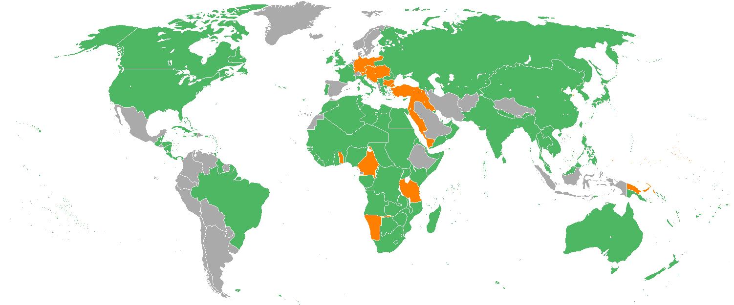
English: Map with the Participants in World War I:
Русский: Карта мира начала XX в. с границами альянсов:
Deutsch: Karte der Beteiligten des Ersten Weltkrieges:
|
| Data | 22 dezëmber 2005 (data di caricamento originaria) |
| Funtana | Transferred from en.wikipedia to Commons. |
| Autur | Helmandsare, Joaopais, El Jaber, Aivazovsky + Vari (Vedi sotto.) |
| Altre versioni |
|


|
Questa immagine (categorizzazione automatica: military map) o tutte le immagini in questa categoria o galleria dovrebbero essere ricreate usando grafica vettoriale come file SVG. Questo offre diversi vantaggi: vedi Commons:Media for cleanup per maggiori informazioni. Se è disponibile una versione in formato SVG di questa immagine, per favore caricala. Dopo aver caricato un file SVG, sostituisci questo avviso con il template {{Vector version available|nome_immagine.svg}}.
|
Lizënza
Aivazovsky at the English Wikipedia, detentore del copyright su quest'opera, dichiara di pubblicarla con la seguente licenza:

|
AL é la lizënza da copié, da dé inant y/o müdé chësc documënt aladô dla lizënza GNU Free Documentation License, Verjiun 1.2 o vigni atra verjiun suandënta publicada dala Free Software Foundation; zënza seziuns che ara ne vá nia da mudé, zënza test söl cuertl ca dant y do ia. Na copia dla lizënza é tla seziun cun le titul Test dla GNU Free Documentation License. |
| Chësc file á la lizënza de destribuziun aladô dla lizënza Creative Commons Attribution-Share Alike 3.0 Unported. | ||
| Atribuzion: Aivazovsky at the English Wikipedia | ||
| ||
| Questo tag di copyright è stato aggiunto nell'ambito dell'aggiornamento della licenza dei progetti Wikimedia. |
Registro originale del caricamento
The original description page was here. All following user names refer to en.wikipedia.
- 2007-02-14 15:32 Aivazovsky 1357×628×8 (30657 bytes) Fixed northern islands of Russia and Norway, fixed borders of Russia's South Caucasus territory
- 2006-05-02 21:54 Helmandsare 1357×628×8 (30663 bytes)
- 2006-01-19 19:34 Joaopais 1357×628×8 (30415 bytes)
- 2006-01-15 12:12 El Jaber 1357×628×8 (45477 bytes) Map with the [[Participants in World War I]]: * <font color="green">''Green''</font>: [[Allies of World War I|Allies]] * <font color="red">''Red''</font>: [[Central Powers]] * <font color="yellow">''Yellow''</font>: [[Neutral Country|Neutral Countries]]
- 2005-12-22 00:53 Joaopais 1357×628×8 (30366 bytes) added Belize and the Guyanas (at the time British and French colonies)
- 2005-12-22 00:19 Joaopais 1357×628×8 (30365 bytes) Map with the [[Participants in World War I]]: * <font color="green">''Green''</font>: [[Allies of World War I|Allies]] * <font color="orange">''Orange''</font>: [[Axis Powers]]
Storia dl documënt
Druca sun na data/ëura per udëi l documënt coche l fo te chël mumënt.
| Data/Ëura | Miniatura | Grandëza | utënt | Cumentar | |
|---|---|---|---|---|---|
| atuel | 20:19, 27 fau 2014 | | 1 502 × 625 (52 KB) | Grachifan | major update |
| 20:18, 27 fau 2014 |  | 1 502 × 625 (60 KB) | Grachifan | major update | |
| 20:17, 27 fau 2014 |  | 1 502 × 625 (54 KB) | Grachifan | major update | |
| 05:28, 31 mer 2013 |  | 1 357 × 628 (45 KB) | OgreBot | (BOT): Reverting to most recent version before archival | |
| 05:28, 31 mer 2013 |  | 1 357 × 628 (30 KB) | OgreBot | (BOT): Uploading old version of file from en.wikipedia; originally uploaded on 2006-05-02 21:54:27 by Helmandsare | |
| 05:27, 31 mer 2013 |  | 1 357 × 628 (30 KB) | OgreBot | (BOT): Uploading old version of file from en.wikipedia; originally uploaded on 2006-01-19 19:34:32 by Joaopais | |
| 05:27, 31 mer 2013 |  | 1 357 × 628 (44 KB) | OgreBot | (BOT): Uploading old version of file from en.wikipedia; originally uploaded on 2006-01-15 12:12:07 by El Jaber | |
| 05:27, 31 mer 2013 |  | 1 357 × 628 (30 KB) | OgreBot | (BOT): Uploading old version of file from en.wikipedia; originally uploaded on 2005-12-22 00:53:03 by Joaopais | |
| 05:27, 31 mer 2013 |  | 1 357 × 628 (30 KB) | OgreBot | (BOT): Uploading old version of file from en.wikipedia; originally uploaded on 2005-12-22 00:19:12 by Joaopais | |
| 01:42, 5 jen 2013 |  | 1 357 × 628 (45 KB) | Tfts | marked Albania as a neutral state |
Coche l document ie stat adurvà
Chësta plata adroa chësc documënt:
Coche l documënt ie stat adurvà ntëur l mond
Ënghe chësta wikis adroa chësc documënt:
- Adurvà sun als.wikipedia.org
- Adurvà sun ar.wikipedia.org
- Adurvà sun az.wikipedia.org
- Adurvà sun be.wikipedia.org
- Adurvà sun bg.wikipedia.org
- Adurvà sun ca.wikipedia.org
- Adurvà sun ceb.wikipedia.org
- Adurvà sun ce.wikipedia.org
- Adurvà sun da.wikipedia.org
- Adurvà sun de.wikipedia.org
- Adurvà sun en.wikipedia.org
- Adurvà sun eo.wikipedia.org
- Adurvà sun es.wikipedia.org
- Adurvà sun eu.wikipedia.org
- Adurvà sun fy.wikipedia.org
- Adurvà sun he.wikipedia.org
- Adurvà sun hr.wikipedia.org
- Adurvà sun hsb.wikipedia.org
- Adurvà sun hy.wikipedia.org
- Adurvà sun id.wikipedia.org
- Adurvà sun ja.wikipedia.org
- Adurvà sun kk.wikipedia.org
- Adurvà sun ko.wikipedia.org
- Adurvà sun la.wikipedia.org
- Adurvà sun ms.wikipedia.org
- Adurvà sun nds.wikipedia.org
- Adurvà sun nl.wikipedia.org
- Adurvà sun pa.wikipedia.org
- Adurvà sun pl.wikipedia.org
- Adurvà sun pt.wikipedia.org
- Adurvà sun ro.wikipedia.org
- Adurvà sun ru.wikipedia.org
- Adurvà sun sh.wikipedia.org
- Adurvà sun si.wikipedia.org
Mostra utilisaziun globala de chësc file.