
File:Yuma arizona map.jpg

Dimenjiuns de chësta odüda danfora:406 x 599 pixel. Autra resoluzions: 162 x 240 pixel | 576 x 850 pixel.
Documënt uriginel (576 × 850 pixels, dimenjiun dl file: 57 KB, MIME type: image/jpeg)
| Descriziun |
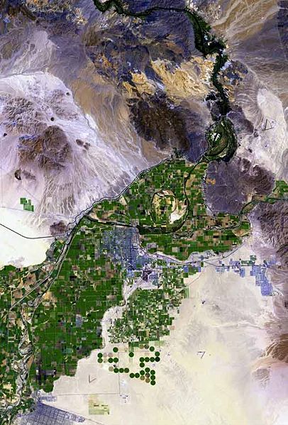
The raw satellite imagery shown in these images was obtained from NASA and/or the US Geological Survey. Post-processing and production by http://www.terraprints.com The en:Colorado River is the border between California, (top, and left), and Arizona, (bottom, and right). The en:Yuma Desert is shown quite prominently, south of Yuma, and the Fortuna Foothills, at the west of the en:Gila Mountains (Yuma County). The Yuma Desert is at the northwest of the Picacho Volcanic field complex, and the great: Gran Desierto de Altar, of north and northwest, Sonora state Mexico. (Note the en:Alluvial fans, especially around the Cargo Muchacho Mountains of California, but throughout the photo.) |
| Data | |
| Funtana | http://www.terraprints.com |
| Autur | http://www.terraprints.com |
Questo file è disponibile in base alla licenza Creative Commons Attribuzione 2.5 Generico
- Tu ies liede:
- da spartì – per cupié, spartësc y manda l lëur
- da mudé – da adaté al lëur
- A chësta condizions:
- atribuzion – Tu mues atribué l lëur te la maniera che à spiegà l autëur o chël che à la lizënza (ma nia te na maniera che l smea che ëi te paiessa).
| Annotations | This image is annotated: View the annotations at Commons |
Storia dl documënt
Druca sun na data/ëura per udëi l documënt coche l fo te chël mumënt.
| Data/Ëura | Miniatura | Grandëza | utënt | Cumentar | |
|---|---|---|---|---|---|
| atuel | 19:49, 25 sët 2007 | | 576 × 850 (57 KB) | Marku1988 | |
| 20:52, 25 uto 2006 |  | 671 × 1 000 (67 KB) | Terraprints | {{Information |Description=The raw satellite imagery shown in these images was obtain from NASA and/or the US Geological Survey. Post-processing and production by http://www.terraprints.com |Source=http://www.terraprints.com |Date=20061025 |Author=http:// |
Coche l document ie stat adurvà
Chësta plata adroa chësc documënt:
Coche l documënt ie stat adurvà ntëur l mond
Ënghe chësta wikis adroa chësc documënt:
- Adurvà sun arz.wikipedia.org
- Adurvà sun ceb.wikipedia.org
- Adurvà sun en.wikipedia.org
- Adurvà sun es.wikipedia.org
- Adurvà sun fr.wikipedia.org
- Adurvà sun fy.wikipedia.org
- Adurvà sun he.wikipedia.org
- Adurvà sun ja.wikipedia.org
- Adurvà sun nn.wikipedia.org
- Adurvà sun www.wikidata.org
- Adurvà sun zh.wikipedia.org