
File:Bridgeport, California, on the eastern slope of Sierra Mountains, and the county seat of Mono County LCCN2013633802.tif

Dimensioni di questa anteprima JPG per questo file TIF: 800 x 404 pixel. Autra resoluzions: 320 x 161 pixel | 640 x 323 pixel | 1 024 x 517 pixel | 1 280 x 646 pixel | 2 560 x 1 292 pixel | 7 360 x 3 714 pixel.
Documënt uriginel (7 360 × 3 714 pixels, dimenjiun dl file: 156,44 MB, MIME type: image/tiff)
Ressumé
| Descriziun |
English: Title: Bridgeport, California, on the eastern slope of Sierra Mountains, and the county seat of Mono County
Physical description: 1 photograph : digital, tiff file, color. Notes: Title, date, and keywords provided by the photographer.; Credit line: The Jon B. Lovelace Collection of California Photographs in Carol M. Highsmith's America Project, Library of Congress, Prints and Photographs Division.; Gift; The Capital Group Companies Charitable Foundation in memory of Jon B. Lovelace; 2012; (DLC/PP-2012:063).; Forms part of: Jon B. Lovelace Collection of California Photographs in Carol M. Highsmith's America Project in the Carol M. Highsmith Archive.; Located near the ghost town Bodie on the eastern slope of the Sierra Mountains, it is the county seat of Mono County. Formerly known as Big Meado, the town attracts tourists, many of whom come to the area for well-known trout streams and lakes. |
||||||||||||||||||||||||||
| Data | Scattata il 23 nuvëmber 2012, 14:21 (secondo i dati Exif) | ||||||||||||||||||||||||||
| Funtana |
Library of Congress
|
||||||||||||||||||||||||||
| Autur |
|
||||||||||||||||||||||||||
| Lizënza (Tó ca danü chësc file) |
No known restrictions on publication.
|
||||||||||||||||||||||||||


| Luogo dello scatto | | Posizione di questa e altre immagini su: OpenStreetMap |
|---|
Lizënza
| Questa opera proviene dalla collezione Carol M. Highsmith Archive della Biblioteca del Congresso. Secondo la biblioteca, non esiste alcuna restrizione nota del diritto di copia sull'uso di quest'opera. Carol M. Highsmith has stipulated that her photographs are in the public domain. Photographs of sculpture or other works of art may be restricted by the copyright of the artist. |
 |
Storia dl documënt
Druca sun na data/ëura per udëi l documënt coche l fo te chël mumënt.
| Data/Ëura | Miniatura | Grandëza | utënt | Cumentar | |
|---|---|---|---|---|---|
| atuel | 03:09, 4 sët 2016 | 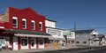 | 7 360 × 3 714 (156,44 MB) | Fæ | LOC 2013633802, Carol M. Highsmith collection. P1619.9159 TIFF (156.4mb) |
Coche l document ie stat adurvà
Chësta plata adroa chësc documënt:
Coche l documënt ie stat adurvà ntëur l mond
Ënghe chësta wikis adroa chësc documënt:
- Adurvà sun bg.wikipedia.org
- Adurvà sun ce.wikipedia.org
- Adurvà sun en.wikipedia.org
- Adurvà sun en.wikivoyage.org
- Adurvà sun eo.wikipedia.org
- Adurvà sun fr.wikipedia.org
- Adurvà sun he.wikivoyage.org
- Adurvà sun hu.wikipedia.org
- Adurvà sun it.wikipedia.org
- Adurvà sun it.wikivoyage.org
- Adurvà sun pl.wikipedia.org
- Adurvà sun ru.wikipedia.org
- Adurvà sun simple.wikipedia.org
- Adurvà sun sr.wikipedia.org
- Adurvà sun tt.wikipedia.org
- Adurvà sun uk.wikipedia.org
- Adurvà sun www.wikidata.org