Raion de Sëuramer Britanich
Aspetto
| Articul per Ladin Gherdëina |
| Raions de Sëuramer Britanics | |
|---|---|
| British Overseas Territories | |
 | |
| Inn | |
| "God Save the King" | |

| |
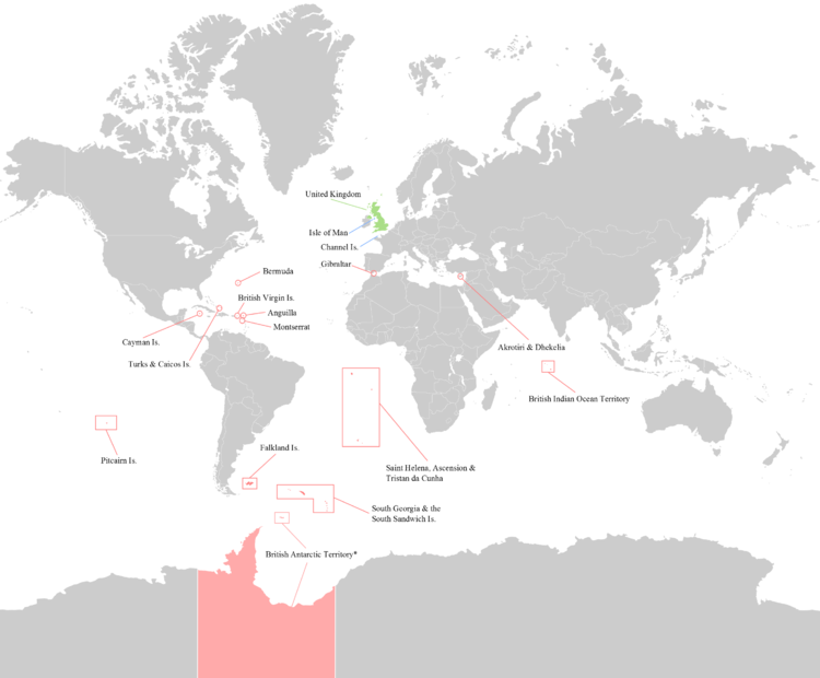
| Posizion dl Riam Unì y di Raions de Sëuramer Britanics. | |
| Stat | Riam Unì |
| Majer raion | Raion Antartich Britanich |
| Rujeneda ufiziela | Nglëisc |
| Spersa | 18 015 km² (de ndut) |
| Populazion | 272 256 (2019) |
I Raions de Sëuramer Britanics ie 14 raions che à n liam storich y costituzionel cul Riam Unì. Chisc ie i ultimi raions dl Mper Britanich y ne fej nia pert dl Riam Unì.
Raions de Sëuramer Britanics
[mudé | muda l codesc]I catordesc Raions de Sëuramer Britanics ie:[1]
| Bandiera | Blason | Inuem | Posizion | Motto | Spersa | PIB (numinel) |
PIB a persona (numinel) |
Populazion | Capitela | Notes |
|---|---|---|---|---|---|---|---|---|---|---|
| Anguilla | Caribich, Ozean Atlantich dl Nord | "Unity, Strength and Endurance" | 91 km²[2] | $299 milions | $20,307 | 14,869 (2019 stima)[3] | The Valley | |||
| Bermuda | Ozean Atlantich dl Nord danter la Azores, la Caribich, Cape Sable Island tl Canada, y Cape Hatteras (its nearest neighbour) in the United States | "Quo fata ferunt" (Latin; "Whither the Fates carry [us]") | 54 km²[4] | $6.464 miliarc | $102,987 | 62,506 (2019 stima)[5] | Hamilton | |||
| Raion Antartich Britanich | Antartis | "Research and discovery" | 1 709 400 km²[2] | 0 50 non-permanent in winter, over 400 in summer (research personnel)[6] |
Rothera (main base) | Subject to the Antarctic Treaty System. | ||||
| Raion Britanich dl Ozean Indian | Ozean Indian | "In tutela nostra Limuria" (Latin; "Limuria is in our charge") | 60 km²[7] | 0 3,000 non-permanent (UK and US military and staff personnel; stima)[8] |
Naval Support Facility Diego Garcia (base) | Claimed by Mauritius. | ||||
| Ijules Vergins Britaniches | Caribich, Ozean Atlantich dl Nord | "Vigilate" (Latin; "Be watchful") | 153 km2 (59 sq mi)[9] | $1,05 miliarc | $48,511 | 31,758 (2018 census)[10] | Road Town | |||
| Ijules Cayman | Caribich | "He hath founded it upon the seas" | 264 km2 (101.9 sq mi)[11] | $4,298 miliarc | $85,474 | 69,656 (2021 census)[11] | George Town | |||
| Ijules Falkland | Ozean Atlantich dl Sud | "Desire the right" | 12 173 km²[4] | $164.5 milions | $70,800 | 3,377 (2019 stima)[12] 1,350 non-permanent (UK military personnel; 2012 stima) |
Stanley | Claimed by Argentina. The Falklands War was fought between the UK and Argentina over control of the islands in 1982. | ||
| Gibraltar | Iberian Peninsula, Continental Europe | "Nulli expugnabilis hosti" (Latin; "No enemy shall expel us") | 6.5 km2 (2.5 sq mi)[13] | $3,08 miliarc | $92,843 | 33,701 (2019 stima)[14] 1,250 non-permanent (UK military personnel; 2012 stima) |
Gibraltar | Claimed by Spania. | ||
| Montserrat | Caribich, Ozean Atlantich dl Nord | "A people of excellence, moulded by nature, nurtured by God" | 101 km2 (39 sq mi)[15] | $61 milions | $12,181 | 5,215 (2019 census)[16] | Plymouth (de jure, but abandoned due to Soufrière Hills volcanic eruption. De facto capital is Brades) | |||
| Ijules Pitcairn, Henderson, Ducie y Oeno | Pacific Ocean | 47 km2 (18 sq mi)[17] | $144,715 | $2,894 | 50 (2018 stima)[18] 6 non-permanent (2014 stima)[19] |
Adamstown | ||||
| Santa Helena, Assenscion y Tristan da Cunha, leprò: |
Ozean Atlantich dl Sud | 420 km2 (162 sq mi) | $55.7 milions | $12,230 | 5,633 (total; 2016 census) | Jamestown | ||||
| Santa Helena | "Loyal and Unshakeable" (Santa Helena) | 4,349 (Saint Helena; 2019 census)[20] | ||||||||
| Ijula de l'Assenscion | 880 (Ascension; stima)[21] 1,000 non-permanent (Ascension; UK military personnel; stima)[21] |
|||||||||
| Tristan da Cunha | "Our faith is our strength" (Tristan da Cunha) | 300 (Tristan da Cunha; stima)[21] 9 non-permanent (Tristan da Cunha; weather personnel) |
||||||||
| Georgia dl Sud y l'ijules Sandwich dl Sud | Ozean Atlantich dl Sud | "Leo terram propriam protegat" (Latin; "Let the lion protect his own land") | 3,903 km2 (1,507 sq mi)[22] | 0 99 non-permanent (officials and research personnel)[23] |
King Edward Point | Claimed by Argentina. The islands were occupied by Argentina during the Falklands War in 1982. | ||||
| Raions de la basa sovrana de Akrotiri y Dhekelia | Cipre, Mer Mediterran | 255 km2 (98 sq mi)[24] | 7,700 (Cypriots; stima) 8,000 non-permanent (UK military personnel and their families; stima) |
Episkopi Cantonment | ||||||
| Ijules Turks y Caicos | Lucayan Archipelago, Ozean Atlantich dl Nord | 948 km2 (366 sq mi)[25] | $1,077 miliarc | £28,589 | 38,191 (2019 stima)[26] | Cockburn Town | ||||
| De ndut | z. 1 727 415 km2 [mancia na referënza] |
z. $16,55 miliarc | z. 272 256[27] | |||||||
Cherta
[mudé | muda l codesc]
Notes
[mudé | muda l codesc]Referënzes
[mudé | muda l codesc]- ↑ "Overseas Territories". UK Overseas Territories Foreign & Commonwealth Office. Archivià da l uriginel ai 5 August 2002. Trat ite ai 8 December 2010.
- ↑ 2,0 2,1 "British Antarctic Territory". Jncc.gov.uk. Archivià da l uriginel ai 14 December 2013. Trat ite ai 8 December 2010.
- ↑ "Anguilla Population 2019". Archivià dal uriginel ai 10 August 2019. Trat ite ai 18 August 2019.
- ↑ 4,0 4,1 "UNdata | record view | Surface area in km2". United Nations. 4 November 2009. Archivià dal uriginel ai 9 July 2013. Trat ite ai 8 December 2010.
- ↑ "Bermuda Population 2019". Archivià dal uriginel ai 16 August 2019. Trat ite ai 18 August 2019.
- ↑ "Commonwealth Secretariat – British Antarctic Territory". Thecommonwealth.org. Archivià da l uriginel ai 5 June 2011. Trat ite ai 8 December 2010.
- ↑ "British Indian Ocean Territory". Jncc.gov.uk. Archivià da l uriginel ai 13 October 2010. Trat ite ai 8 December 2010.
- ↑ "Commonwealth Secretariat – British Indian Ocean Territory". Thecommonwealth.org. Archivià da l uriginel ai 5 June 2011. Trat ite ai 8 December 2010.
- ↑ "British Virgin Islands (BVI)". CIA World Factbook. Archivià dal uriginel ai 9 January 2021. Trat ite ai 14 August 2019.
- ↑ "British Virgin Islands (BVI)". 13 October 2010. Archivià da l uriginel ai 13 October 2010.
- ↑ 11,0 11,1 "Economics and Statistics Office - Labour Force Survey Report Spring 2018" (PDF). www.eso.ky. Cayman Islands Economics and Statistics Office. August 2018. Archivià (PDF) dal uriginel ai 13 November 2018. Trat ite ai 26 November 2018.
- ↑ "Falkland Islands Population 2019". Archivià dal uriginel ai 7 August 2019. Trat ite ai 18 August 2019.
- ↑ "Gibraltar". Jncc.gov.uk. Archivià da l uriginel ai 17 December 2013. Trat ite ai 8 December 2010.
- ↑ "Gibraltar Population 2019". Archivià dal uriginel ai 25 August 2019. Trat ite ai 18 August 2019.
- ↑ "Montserrat". CIA World Factbook. Archivià dal uriginel ai 14 March 2021. Trat ite ai 14 August 2019.
- ↑ "Montserrat". 13 October 2010. Archivià da l uriginel ai 13 October 2010.
- ↑ "Pitcairn Island". Jncc.gov.uk. Archivià da l uriginel ai 13 October 2010. Trat ite ai 8 December 2010.
- ↑ "Pitcairn Islands Tourism | Come Explore... The Legendary Pitcairn Islands". Visitpitcairn.pn. Archivià dal uriginel ai 19 September 2019. Trat ite ai 3 January 2018.
- ↑ "Pitcairn Residents" Archived 7 dezëmber 2014 te la Wayback Machine. puc.edu. Retrieved 7 September 2016.
- ↑ "St Helena Government". St Helena Government. 30 July 2019. Archivià dal uriginel ai 7 August 2019. Trat ite ai 14 August 2019.
- ↑ 21,0 21,1 21,2 "St Helena, Ascension, Tristan da Cunha profiles". BBC. 16 March 2016. Archivià dal uriginel ai 30 May 2016. Trat ite ai 25 June 2016.
- ↑ South Georgia and South Sandwich Islands Archived 15 jené 2021 te la Wayback Machine. The World Factbook. Central Intelligence Agency.
- ↑ "Population of Grytviken, South Georgia and the South Sandwich Islands". Population.mongabay.com. 31 March 2009. Archivià da l uriginel ai 17 July 2011. Trat ite ai 8 December 2010.
- ↑ "SBA Cyprus". Jncc.gov.uk. Archivià da l uriginel ai 13 October 2010. Trat ite ai 8 December 2010.
- ↑ "Turks and Caicos Islands". Encyclopedia Britannica.
- ↑ "Turks and Caicos Islands Population 2019". Archivià dal uriginel ai 10 August 2019. Trat ite ai 18 August 2019.
- ↑ Fal tles notes: Errore nell'uso del marcatore
<ref>: non è stato indicato alcun testo per il marcatoreHCFAC 2019


